You are here: Home > Network List > TA - USArray Transportable Network (new EarthScope stations) Stations List
> Station MSTX Muleshoe, TX, USA > Earthquake Result Viewer
MSTX Muleshoe, TX, USA - Earthquake Result Viewer
*The percent match for this event was below the threshold and hence no stack was calculated.
| Earthquake location: |
Off East Coast Of Honshu, Japan |
| Earthquake latitude/longitude: |
37.8/143.6 |
| Earthquake time(UTC): |
2012/12/07 (342) 08:48:13 GMT |
| Earthquake Depth: |
20 km |
| Earthquake Magnitude: |
5.5 MB |
| Earthquake Catalog/Contributor: |
WHDF/NEIC |
|
| Network: |
TA USArray Transportable Network (new EarthScope stations) |
| Station: |
MSTX Muleshoe, TX, USA |
| Lat/Lon: |
33.97 N/102.77 W |
| Elevation: |
1167 m |
|
| Distance: |
85.6 deg |
| Az: |
49.787 deg |
| Baz: |
313.314 deg |
| Ray Param: |
$rayparam |
*The percent match for this event was below the threshold and hence was not used in the summary stack. |
|
| Radial Match: |
65.43551 % |
| Radial Bump: |
400 |
| Transverse Match: |
58.448196 % |
| Transverse Bump: |
344 |
| SOD ConfigId: |
488671 |
| Insert Time: |
2013-03-29 05:21:52.009 +0000 |
| GWidth: |
2.5 |
| Max Bumps: |
400 |
| Tol: |
0.001 |
|
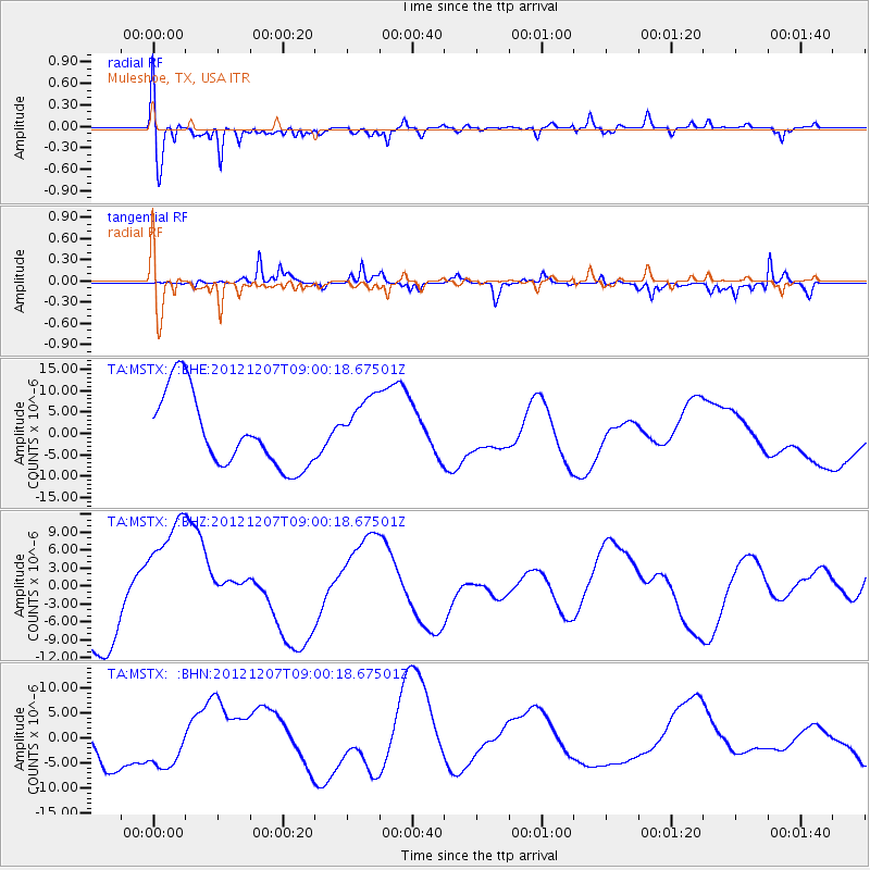
Signal To Noise
| Channel | StoN | STA | LTA |
| TA:MSTX: :BHZ:20121207T09:00:18.67501Z | 1.4935772 | 1.1142588E-5 | 7.460336E-6 |
| TA:MSTX: :BHN:20121207T09:00:18.67501Z | 0.9860851 | 4.7240255E-6 | 4.7906874E-6 |
| TA:MSTX: :BHE:20121207T09:00:18.67501Z | 0.8451015 | 7.191025E-6 | 8.509067E-6 |
| Arrivals |
| Ps | |
| PpPs | |
| PsPs/PpSs | |


