You are here: Home > Network List > TA - USArray Transportable Network (new EarthScope stations) Stations List
> Station O41A Passley's Farm, La Prairie, IL, USA > Earthquake Result Viewer
O41A Passley's Farm, La Prairie, IL, USA - Earthquake Result Viewer
| Earthquake location: |
Off East Coast Of Honshu, Japan |
| Earthquake latitude/longitude: |
37.8/143.6 |
| Earthquake time(UTC): |
2012/12/07 (342) 08:48:13 GMT |
| Earthquake Depth: |
20 km |
| Earthquake Magnitude: |
5.5 MB |
| Earthquake Catalog/Contributor: |
WHDF/NEIC |
|
| Network: |
TA USArray Transportable Network (new EarthScope stations) |
| Station: |
O41A Passley's Farm, La Prairie, IL, USA |
| Lat/Lon: |
40.12 N/90.88 W |
| Elevation: |
203 m |
|
| Distance: |
87.8 deg |
| Az: |
38.662 deg |
| Baz: |
319.83 deg |
| Ray Param: |
0.04307933 |
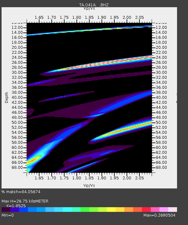
| Estimated Moho Depth: |
26.75 km |
| Estimated Crust Vp/Vs: |
1.85 |
| Assumed Crust Vp: |
6.498 km/s |
| Estimated Crust Vs: |
3.507 km/s |
| Estimated Crust Poisson's Ratio: |
0.29 |
|
| Radial Match: |
84.05674 % |
| Radial Bump: |
400 |
| Transverse Match: |
52.832306 % |
| Transverse Bump: |
335 |
| SOD ConfigId: |
488671 |
| Insert Time: |
2013-03-29 05:23:41.112 +0000 |
| GWidth: |
2.5 |
| Max Bumps: |
400 |
| Tol: |
0.001 |
|

Signal To Noise
| Channel | StoN | STA | LTA |
| TA:O41A: :BHZ:20121207T09:00:28.92501Z | 6.276016 | 1.1024507E-5 | 1.7566091E-6 |
| TA:O41A: :BHN:20121207T09:00:28.92501Z | 0.58593816 | 3.5222904E-6 | 6.011369E-6 |
| TA:O41A: :BHE:20121207T09:00:28.92501Z | 1.8035672 | 1.1910281E-5 | 6.6037355E-6 |
| Arrivals |
| Ps | 3.6 SECOND |
| PpPs | 11 SECOND |
| PsPs/PpSs | 15 SECOND |


