You are here: Home > Network List > TA - USArray Transportable Network (new EarthScope stations) Stations List
> Station O45A Potomac, IL, USA > Earthquake Result Viewer
O45A Potomac, IL, USA - Earthquake Result Viewer
| Earthquake location: |
Off East Coast Of Honshu, Japan |
| Earthquake latitude/longitude: |
37.8/143.6 |
| Earthquake time(UTC): |
2012/12/07 (342) 08:48:13 GMT |
| Earthquake Depth: |
20 km |
| Earthquake Magnitude: |
5.5 MB |
| Earthquake Catalog/Contributor: |
WHDF/NEIC |
|
| Network: |
TA USArray Transportable Network (new EarthScope stations) |
| Station: |
O45A Potomac, IL, USA |
| Lat/Lon: |
40.25 N/87.72 W |
| Elevation: |
208 m |
|
| Distance: |
89.2 deg |
| Az: |
36.702 deg |
| Baz: |
321.807 deg |
| Ray Param: |
0.042023752 |
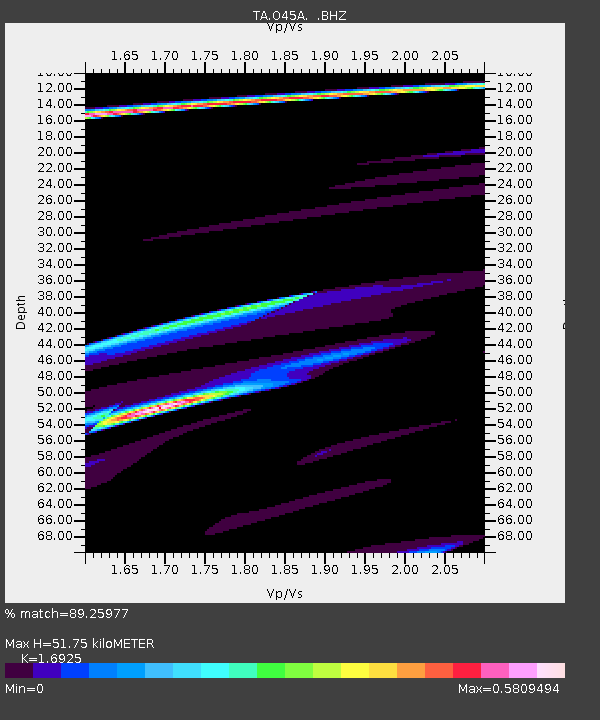
| Estimated Moho Depth: |
51.75 km |
| Estimated Crust Vp/Vs: |
1.69 |
| Assumed Crust Vp: |
6.498 km/s |
| Estimated Crust Vs: |
3.839 km/s |
| Estimated Crust Poisson's Ratio: |
0.23 |
|
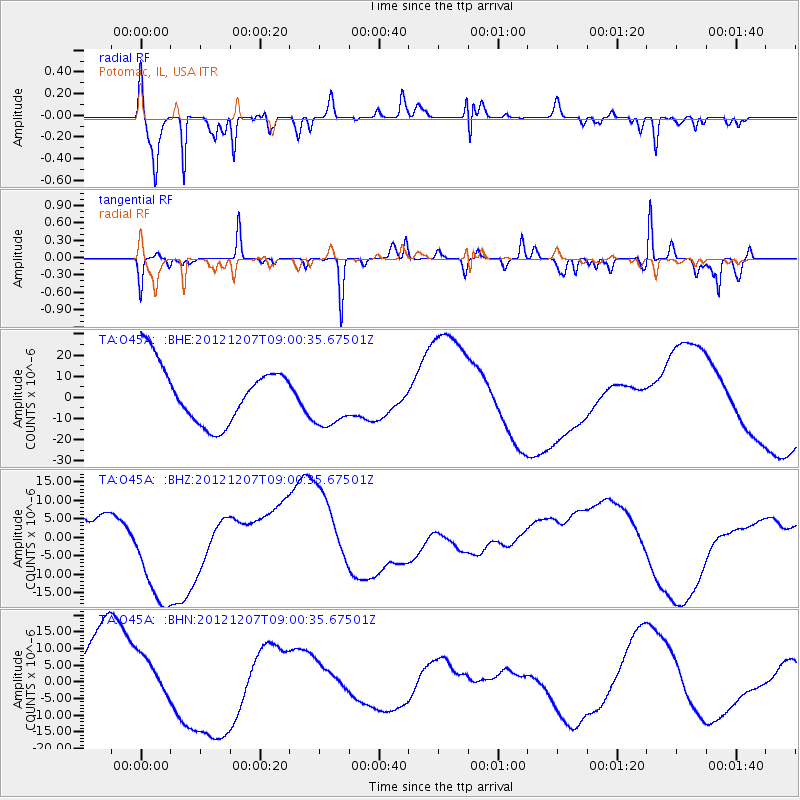
| Radial Match: |
89.25977 % |
| Radial Bump: |
314 |
| Transverse Match: |
75.79302 % |
| Transverse Bump: |
248 |
| SOD ConfigId: |
488671 |
| Insert Time: |
2013-03-29 05:24:54.319 +0000 |
| GWidth: |
2.5 |
| Max Bumps: |
400 |
| Tol: |
0.001 |
|
Signal To Noise
| Channel | StoN | STA | LTA |
| TA:O45A: :BHZ:20121207T09:00:35.67501Z | 3.761336 | 1.6043154E-5 | 4.2652805E-6 |
| TA:O45A: :BHN:20121207T09:00:35.67501Z | 0.43159 | 6.29437E-6 | 1.4584141E-5 |
| TA:O45A: :BHE:20121207T09:00:35.67501Z | 1.0145513 | 1.3843309E-5 | 1.3644759E-5 |
| Arrivals |
| Ps | 5.6 SECOND |
| PpPs | 21 SECOND |
| PsPs/PpSs | 27 SECOND |


