You are here: Home > Network List > TA - USArray Transportable Network (new EarthScope stations) Stations List
> Station M44A Midewin, Midewin Nat. Tallgrass Prarie, IL, USA > Earthquake Result Viewer
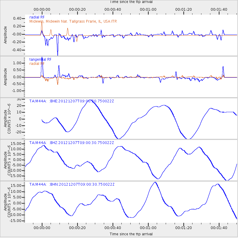
M44A Midewin, Midewin Nat. Tallgrass Prarie, IL, USA - Earthquake Result Viewer
*The percent match for this event was below the threshold and hence no stack was calculated.
| Earthquake location: |
Off East Coast Of Honshu, Japan |
| Earthquake latitude/longitude: |
37.8/143.6 |
| Earthquake time(UTC): |
2012/12/07 (342) 08:48:13 GMT |
| Earthquake Depth: |
20 km |
| Earthquake Magnitude: |
5.5 MB |
| Earthquake Catalog/Contributor: |
WHDF/NEIC |
|
| Network: |
TA USArray Transportable Network (new EarthScope stations) |
| Station: |
M44A Midewin, Midewin Nat. Tallgrass Prarie, IL, USA |
| Lat/Lon: |
41.39 N/88.04 W |
| Elevation: |
207 m |
|
| Distance: |
88.1 deg |
| Az: |
36.186 deg |
| Baz: |
321.587 deg |
| Ray Param: |
$rayparam |
*The percent match for this event was below the threshold and hence was not used in the summary stack. |
|
| Radial Match: |
91.479065 % |
| Radial Bump: |
393 |
| Transverse Match: |
63.388405 % |
| Transverse Bump: |
299 |
| SOD ConfigId: |
488671 |
| Insert Time: |
2013-03-29 05:25:04.062 +0000 |
| GWidth: |
2.5 |
| Max Bumps: |
400 |
| Tol: |
0.001 |
|
Signal To Noise
| Channel | StoN | STA | LTA |
| TA:M44A: :BHZ:20121207T09:00:30.750022Z | 2.03479 | 1.5492815E-5 | 7.613962E-6 |
| TA:M44A: :BHN:20121207T09:00:30.750022Z | 1.1216979 | 1.1858652E-5 | 1.05720555E-5 |
| TA:M44A: :BHE:20121207T09:00:30.750022Z | 1.9390782 | 2.0459953E-5 | 1.0551382E-5 |
| Arrivals |
| Ps | |
| PpPs | |
| PsPs/PpSs | |


