You are here: Home > Network List > TA - USArray Transportable Network (new EarthScope stations) Stations List
> Station V50A Pikevile, TN, USA > Earthquake Result Viewer
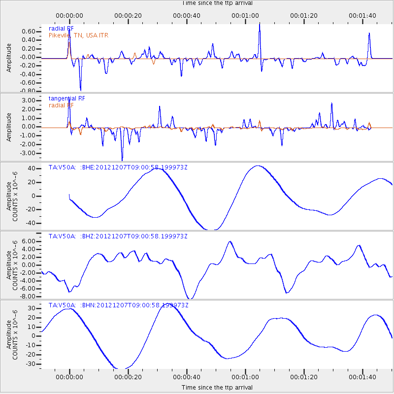
V50A Pikevile, TN, USA - Earthquake Result Viewer
*The percent match for this event was below the threshold and hence no stack was calculated.
| Earthquake location: |
Off East Coast Of Honshu, Japan |
| Earthquake latitude/longitude: |
37.8/143.6 |
| Earthquake time(UTC): |
2012/12/07 (342) 08:48:13 GMT |
| Earthquake Depth: |
20 km |
| Earthquake Magnitude: |
5.5 MB |
| Earthquake Catalog/Contributor: |
WHDF/NEIC |
|
| Network: |
TA USArray Transportable Network (new EarthScope stations) |
| Station: |
V50A Pikevile, TN, USA |
| Lat/Lon: |
35.67 N/85.10 W |
| Elevation: |
287 m |
|
| Distance: |
94.1 deg |
| Az: |
37.829 deg |
| Baz: |
323.384 deg |
| Ray Param: |
$rayparam |
*The percent match for this event was below the threshold and hence was not used in the summary stack. |
|
| Radial Match: |
70.70415 % |
| Radial Bump: |
327 |
| Transverse Match: |
76.36934 % |
| Transverse Bump: |
228 |
| SOD ConfigId: |
488671 |
| Insert Time: |
2013-03-29 05:26:31.814 +0000 |
| GWidth: |
2.5 |
| Max Bumps: |
400 |
| Tol: |
0.001 |
|
Signal To Noise
| Channel | StoN | STA | LTA |
| TA:V50A: :BHZ:20121207T09:00:58.199973Z | 2.3643088 | 6.324298E-6 | 2.6749035E-6 |
| TA:V50A: :BHN:20121207T09:00:58.199973Z | 2.693331 | 3.312986E-5 | 1.2300702E-5 |
| TA:V50A: :BHE:20121207T09:00:58.199973Z | 2.7923553 | 4.724723E-5 | 1.6920209E-5 |
| Arrivals |
| Ps | |
| PpPs | |
| PsPs/PpSs | |


