You are here: Home > Network List > TA - USArray Transportable Network (new EarthScope stations) Stations List
> Station M49A Liberty Center, OH, USA > Earthquake Result Viewer
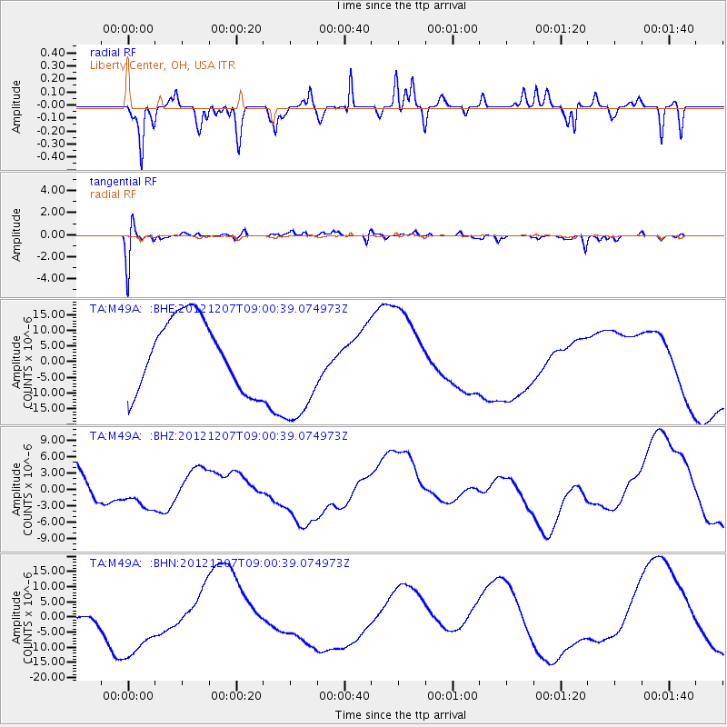
M49A Liberty Center, OH, USA - Earthquake Result Viewer
*The percent match for this event was below the threshold and hence no stack was calculated.
| Earthquake location: |
Off East Coast Of Honshu, Japan |
| Earthquake latitude/longitude: |
37.8/143.6 |
| Earthquake time(UTC): |
2012/12/07 (342) 08:48:13 GMT |
| Earthquake Depth: |
20 km |
| Earthquake Magnitude: |
5.5 MB |
| Earthquake Catalog/Contributor: |
WHDF/NEIC |
|
| Network: |
TA USArray Transportable Network (new EarthScope stations) |
| Station: |
M49A Liberty Center, OH, USA |
| Lat/Lon: |
41.47 N/83.98 W |
| Elevation: |
203 m |
|
| Distance: |
89.9 deg |
| Az: |
33.694 deg |
| Baz: |
324.227 deg |
| Ray Param: |
$rayparam |
*The percent match for this event was below the threshold and hence was not used in the summary stack. |
|
| Radial Match: |
61.769394 % |
| Radial Bump: |
400 |
| Transverse Match: |
66.990166 % |
| Transverse Bump: |
400 |
| SOD ConfigId: |
488671 |
| Insert Time: |
2013-03-29 05:27:19.190 +0000 |
| GWidth: |
2.5 |
| Max Bumps: |
400 |
| Tol: |
0.001 |
|
Signal To Noise
| Channel | StoN | STA | LTA |
| TA:M49A: :BHZ:20121207T09:00:39.074973Z | 0.83245987 | 2.92709E-6 | 3.5161934E-6 |
| TA:M49A: :BHN:20121207T09:00:39.074973Z | 1.5688304 | 1.1895961E-5 | 7.582694E-6 |
| TA:M49A: :BHE:20121207T09:00:39.074973Z | 1.6551363 | 1.8518795E-5 | 1.1188682E-5 |
| Arrivals |
| Ps | |
| PpPs | |
| PsPs/PpSs | |


