You are here: Home > Network List > TA - USArray Transportable Network (new EarthScope stations) Stations List
> Station M50A Fremont, OH, USA > Earthquake Result Viewer
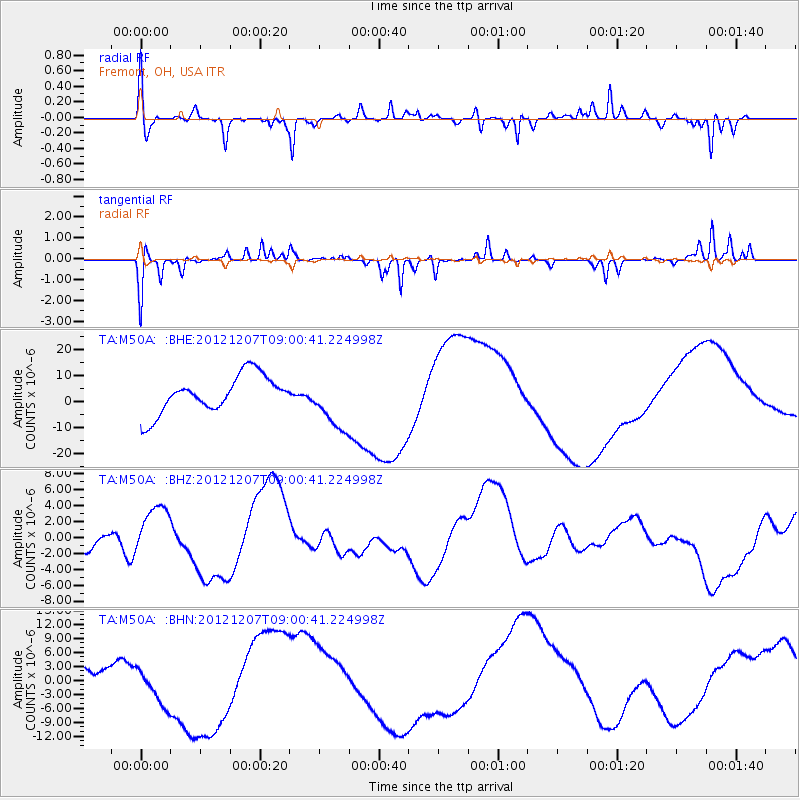
M50A Fremont, OH, USA - Earthquake Result Viewer
*The percent match for this event was below the threshold and hence no stack was calculated.
| Earthquake location: |
Off East Coast Of Honshu, Japan |
| Earthquake latitude/longitude: |
37.8/143.6 |
| Earthquake time(UTC): |
2012/12/07 (342) 08:48:13 GMT |
| Earthquake Depth: |
20 km |
| Earthquake Magnitude: |
5.5 MB |
| Earthquake Catalog/Contributor: |
WHDF/NEIC |
|
| Network: |
TA USArray Transportable Network (new EarthScope stations) |
| Station: |
M50A Fremont, OH, USA |
| Lat/Lon: |
41.40 N/83.04 W |
| Elevation: |
176 m |
|
| Distance: |
90.4 deg |
| Az: |
33.164 deg |
| Baz: |
324.843 deg |
| Ray Param: |
$rayparam |
*The percent match for this event was below the threshold and hence was not used in the summary stack. |
|
| Radial Match: |
59.005623 % |
| Radial Bump: |
291 |
| Transverse Match: |
50.83308 % |
| Transverse Bump: |
222 |
| SOD ConfigId: |
488671 |
| Insert Time: |
2013-03-29 05:27:22.688 +0000 |
| GWidth: |
2.5 |
| Max Bumps: |
400 |
| Tol: |
0.001 |
|
Signal To Noise
| Channel | StoN | STA | LTA |
| TA:M50A: :BHZ:20121207T09:00:41.224998Z | 0.8931065 | 2.6094629E-6 | 2.9217822E-6 |
| TA:M50A: :BHN:20121207T09:00:41.224998Z | 2.2486093 | 4.649783E-6 | 2.0678485E-6 |
| TA:M50A: :BHE:20121207T09:00:41.224998Z | 1.4742097 | 1.0631893E-5 | 7.2119274E-6 |
| Arrivals |
| Ps | |
| PpPs | |
| PsPs/PpSs | |


