You are here: Home > Network List > GE - GEOFON Stations List
> Station SNAA GEOFON/AWI Station Sanae, Antarctica > Earthquake Result Viewer
SNAA GEOFON/AWI Station Sanae, Antarctica - Earthquake Result Viewer
| Earthquake location: |
North Island, New Zealand |
| Earthquake latitude/longitude: |
-38.4/176.1 |
| Earthquake time(UTC): |
2012/12/07 (342) 18:19:06 GMT |
| Earthquake Depth: |
163 km |
| Earthquake Magnitude: |
5.7 MB, 6.3 MW, 6.4 MW |
| Earthquake Catalog/Contributor: |
WHDF/NEIC |
|
| Network: |
GE GEOFON |
| Station: |
SNAA GEOFON/AWI Station Sanae, Antarctica |
| Lat/Lon: |
71.67 S/2.84 W |
| Elevation: |
846 m |
|
| Distance: |
70.2 deg |
| Az: |
180.368 deg |
| Baz: |
179.086 deg |
| Ray Param: |
0.054696947 |
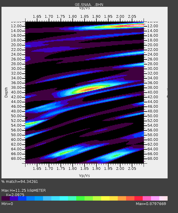
| Estimated Moho Depth: |
11.25 km |
| Estimated Crust Vp/Vs: |
2.10 |
| Assumed Crust Vp: |
6.43 km/s |
| Estimated Crust Vs: |
3.065 km/s |
| Estimated Crust Poisson's Ratio: |
0.35 |
|
| Radial Match: |
94.34261 % |
| Radial Bump: |
400 |
| Transverse Match: |
59.483498 % |
| Transverse Bump: |
400 |
| SOD ConfigId: |
488671 |
| Insert Time: |
2013-03-29 05:34:18.321 +0000 |
| GWidth: |
2.5 |
| Max Bumps: |
400 |
| Tol: |
0.001 |
|
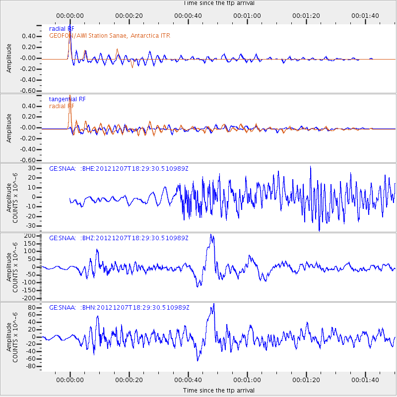
Signal To Noise
| Channel | StoN | STA | LTA |
| GE:SNAA: :BHZ:20121207T18:29:30.510989Z | 3.2416873 | 1.7744713E-5 | 5.4739126E-6 |
| GE:SNAA: :BHN:20121207T18:29:30.510989Z | 2.4840121 | 8.650649E-6 | 3.482531E-6 |
| GE:SNAA: :BHE:20121207T18:29:30.510989Z | 2.5929313 | 6.6692533E-6 | 2.5720904E-6 |
| Arrivals |
| Ps | 2.0 SECOND |
| PpPs | 5.3 SECOND |
| PsPs/PpSs | 7.2 SECOND |


