You are here: Home > Network List > TA - USArray Transportable Network (new EarthScope stations) Stations List
> Station H17A Grant Village (NPS), Yellowstone Nt. Park, WY, USA > Earthquake Result Viewer
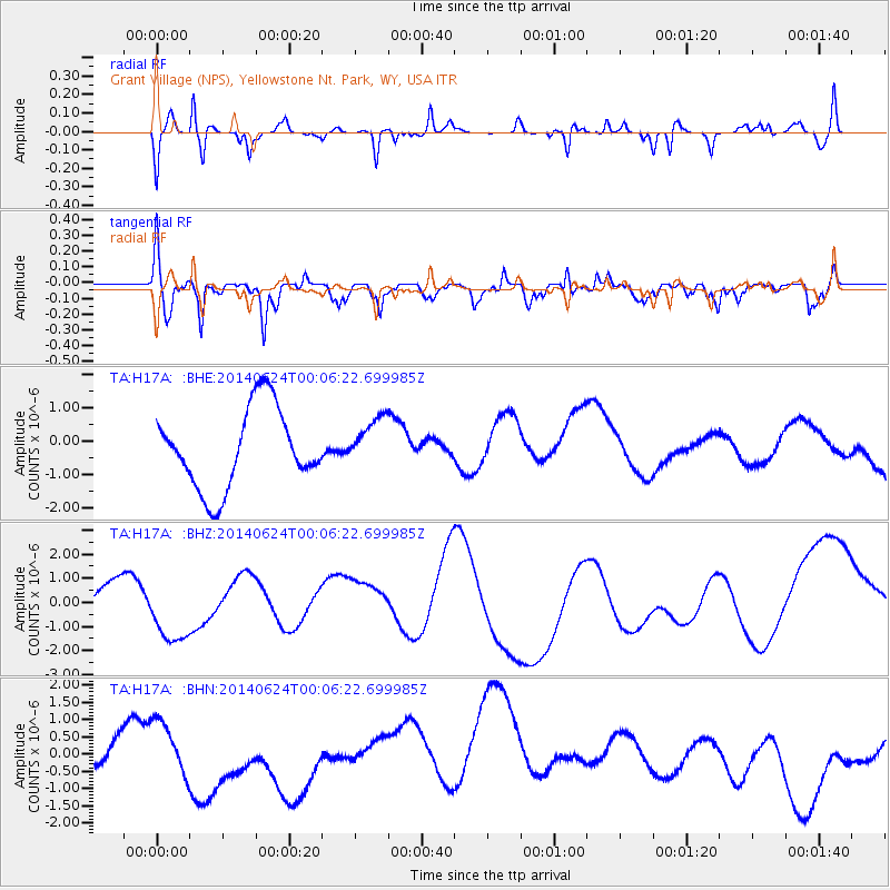
H17A Grant Village (NPS), Yellowstone Nt. Park, WY, USA - Earthquake Result Viewer
*The percent match for this event was below the threshold and hence no stack was calculated.
| Earthquake location: |
Kermadec Islands, New Zealand |
| Earthquake latitude/longitude: |
-30.2/-177.5 |
| Earthquake time(UTC): |
2014/06/23 (174) 23:53:27 GMT |
| Earthquake Depth: |
10 km |
| Earthquake Magnitude: |
5.2 mb |
| Earthquake Catalog/Contributor: |
ISC/ISC |
|
| Network: |
TA USArray Transportable Network (new EarthScope stations) |
| Station: |
H17A Grant Village (NPS), Yellowstone Nt. Park, WY, USA |
| Lat/Lon: |
44.40 N/110.58 W |
| Elevation: |
2400 m |
|
| Distance: |
96.0 deg |
| Az: |
41.532 deg |
| Baz: |
233.23 deg |
| Ray Param: |
$rayparam |
*The percent match for this event was below the threshold and hence was not used in the summary stack. |
|
| Radial Match: |
60.710976 % |
| Radial Bump: |
382 |
| Transverse Match: |
66.93767 % |
| Transverse Bump: |
400 |
| SOD ConfigId: |
3390531 |
| Insert Time: |
2019-04-12 11:56:50.224 +0000 |
| GWidth: |
2.5 |
| Max Bumps: |
400 |
| Tol: |
0.001 |
|
Signal To Noise
| Channel | StoN | STA | LTA |
| TA:H17A: :BHZ:20140624T00:06:22.699985Z | 1.1036477 | 1.1164288E-6 | 1.0115808E-6 |
| TA:H17A: :BHN:20140624T00:06:22.699985Z | 1.814083 | 6.9264337E-7 | 3.818146E-7 |
| TA:H17A: :BHE:20140624T00:06:22.699985Z | 0.6325752 | 7.529732E-7 | 1.19033E-6 |
| Arrivals |
| Ps | |
| PpPs | |
| PsPs/PpSs | |


