You are here: Home > Network List > TA - USArray Transportable Network (new EarthScope stations) Stations List
> Station A04D Lummi Island, WA, USA > Earthquake Result Viewer
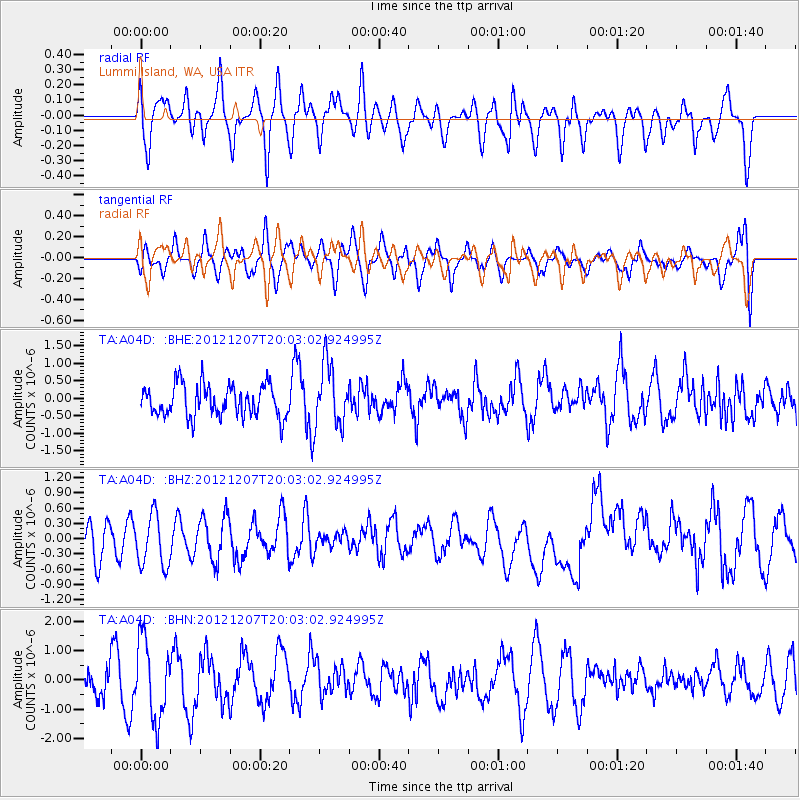
A04D Lummi Island, WA, USA - Earthquake Result Viewer
*The percent match for this event was below the threshold and hence no stack was calculated.
| Earthquake location: |
Eastern New Guinea Reg., P.N.G. |
| Earthquake latitude/longitude: |
-7.7/147.0 |
| Earthquake time(UTC): |
2012/12/07 (342) 19:50:23 GMT |
| Earthquake Depth: |
140 km |
| Earthquake Magnitude: |
5.5 MB, 5.7 MW |
| Earthquake Catalog/Contributor: |
WHDF/NEIC |
|
| Network: |
TA USArray Transportable Network (new EarthScope stations) |
| Station: |
A04D Lummi Island, WA, USA |
| Lat/Lon: |
48.72 N/122.71 W |
| Elevation: |
13 m |
|
| Distance: |
95.9 deg |
| Az: |
41.742 deg |
| Baz: |
265.196 deg |
| Ray Param: |
$rayparam |
*The percent match for this event was below the threshold and hence was not used in the summary stack. |
|
| Radial Match: |
58.172676 % |
| Radial Bump: |
400 |
| Transverse Match: |
37.1656 % |
| Transverse Bump: |
400 |
| SOD ConfigId: |
488671 |
| Insert Time: |
2013-03-29 05:39:49.161 +0000 |
| GWidth: |
2.5 |
| Max Bumps: |
400 |
| Tol: |
0.001 |
|
Signal To Noise
| Channel | StoN | STA | LTA |
| TA:A04D: :BHZ:20121207T20:03:02.924995Z | 1.7542249 | 5.0556963E-7 | 2.8820116E-7 |
| TA:A04D: :BHN:20121207T20:03:02.924995Z | 3.0634575 | 1.3199841E-6 | 4.308805E-7 |
| TA:A04D: :BHE:20121207T20:03:02.924995Z | 1.96596 | 8.921435E-7 | 4.5379534E-7 |
| Arrivals |
| Ps | |
| PpPs | |
| PsPs/PpSs | |


