You are here: Home > Network List > TA - USArray Transportable Network (new EarthScope stations) Stations List
> Station POKR Poker Plat Research Range, AK, USA > Earthquake Result Viewer
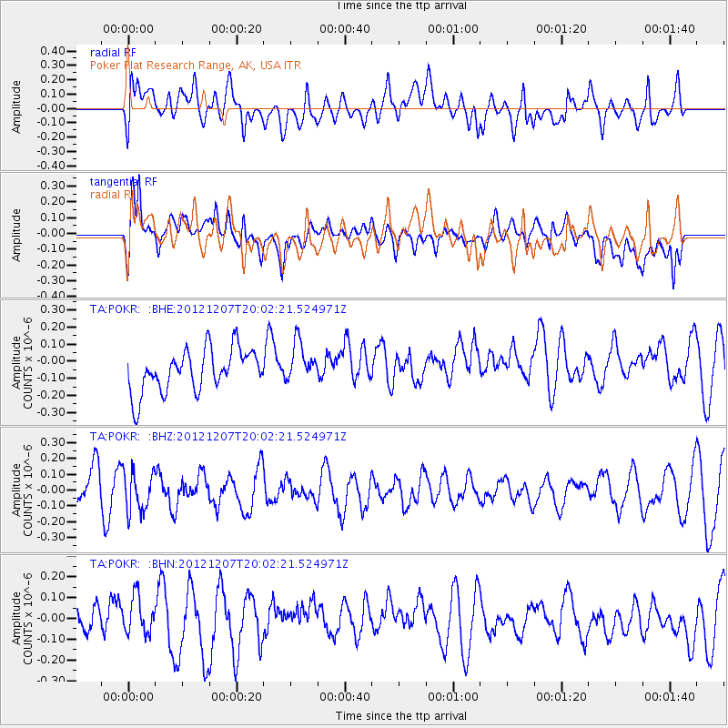
POKR Poker Plat Research Range, AK, USA - Earthquake Result Viewer
*The percent match for this event was below the threshold and hence no stack was calculated.
| Earthquake location: |
Eastern New Guinea Reg., P.N.G. |
| Earthquake latitude/longitude: |
-7.7/147.0 |
| Earthquake time(UTC): |
2012/12/07 (342) 19:50:23 GMT |
| Earthquake Depth: |
140 km |
| Earthquake Magnitude: |
5.5 MB, 5.7 MW |
| Earthquake Catalog/Contributor: |
WHDF/NEIC |
|
| Network: |
TA USArray Transportable Network (new EarthScope stations) |
| Station: |
POKR Poker Plat Research Range, AK, USA |
| Lat/Lon: |
65.12 N/147.43 W |
| Elevation: |
501 m |
|
| Distance: |
87.0 deg |
| Az: |
22.699 deg |
| Baz: |
244.693 deg |
| Ray Param: |
$rayparam |
*The percent match for this event was below the threshold and hence was not used in the summary stack. |
|
| Radial Match: |
56.83241 % |
| Radial Bump: |
400 |
| Transverse Match: |
52.16573 % |
| Transverse Bump: |
400 |
| SOD ConfigId: |
488671 |
| Insert Time: |
2013-03-29 05:40:02.977 +0000 |
| GWidth: |
2.5 |
| Max Bumps: |
400 |
| Tol: |
0.001 |
|
Signal To Noise
| Channel | StoN | STA | LTA |
| TA:POKR: :BHZ:20121207T20:02:21.524971Z | 1.0459707 | 1.2758855E-7 | 1.21981E-7 |
| TA:POKR: :BHN:20121207T20:02:21.524971Z | 0.64957386 | 8.998414E-8 | 1.3852795E-7 |
| TA:POKR: :BHE:20121207T20:02:21.524971Z | 0.95066 | 1.1832282E-7 | 1.2446388E-7 |
| Arrivals |
| Ps | |
| PpPs | |
| PsPs/PpSs | |


