You are here: Home > Network List > CZ - Czech Regional Seismic Network Stations List
> Station KHC CZ.KHC > Earthquake Result Viewer
KHC CZ.KHC - Earthquake Result Viewer
| Earthquake location: |
Southern Xinjiang, China |
| Earthquake latitude/longitude: |
35.5/81.5 |
| Earthquake time(UTC): |
2008/03/20 (080) 22:32:57 GMT |
| Earthquake Depth: |
10 km |
| Earthquake Magnitude: |
6.3 MB, 7.3 MS, 7.2 MW, 7.1 MW |
| Earthquake Catalog/Contributor: |
WHDF/NEIC |
|
| Network: |
CZ Czech Regional Seismic Network |
| Station: |
KHC CZ.KHC |
| Lat/Lon: |
49.13 N/13.58 E |
| Elevation: |
700 m |
|
| Distance: |
50.4 deg |
| Az: |
307.824 deg |
| Baz: |
78.922 deg |
| Ray Param: |
0.06809037 |
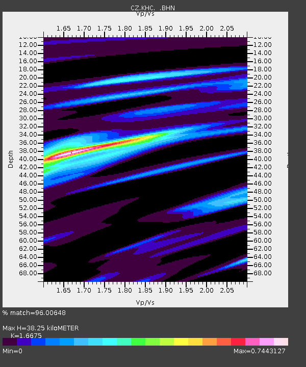
| Estimated Moho Depth: |
38.25 km |
| Estimated Crust Vp/Vs: |
1.67 |
| Assumed Crust Vp: |
6.276 km/s |
| Estimated Crust Vs: |
3.764 km/s |
| Estimated Crust Poisson's Ratio: |
0.22 |
|
| Radial Match: |
96.00648 % |
| Radial Bump: |
275 |
| Transverse Match: |
92.60973 % |
| Transverse Bump: |
400 |
| SOD ConfigId: |
2564 |
| Insert Time: |
2010-02-27 01:23:44.355 +0000 |
| GWidth: |
2.5 |
| Max Bumps: |
400 |
| Tol: |
0.001 |
|
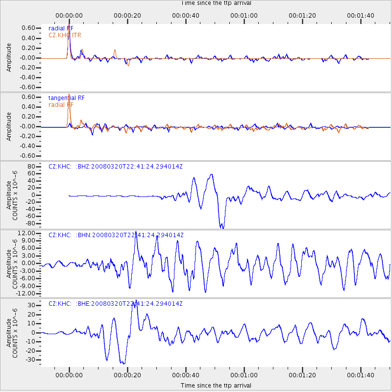
Signal To Noise
| Channel | StoN | STA | LTA |
| CZ:KHC: :BHN:20080320T22:41:24.294014Z | 0.77053213 | 5.7638664E-7 | 7.4803717E-7 |
| CZ:KHC: :BHE:20080320T22:41:24.294014Z | 3.2072685 | 2.0640018E-6 | 6.4353884E-7 |
| CZ:KHC: :BHZ:20080320T22:41:24.294014Z | 4.200415 | 3.3437727E-6 | 7.960577E-7 |
| Arrivals |
| Ps | 4.3 SECOND |
| PpPs | 15 SECOND |
| PsPs/PpSs | 20 SECOND |


