You are here: Home > Network List > CN - Canadian National Seismograph Network Stations List
> Station INK INUVIK, NT > Earthquake Result Viewer
INK INUVIK, NT - Earthquake Result Viewer
*The percent match for this event was below the threshold and hence no stack was calculated.
| Earthquake location: |
Off East Coast Of Honshu, Japan |
| Earthquake latitude/longitude: |
37.7/143.8 |
| Earthquake time(UTC): |
2012/12/07 (342) 23:00:00 GMT |
| Earthquake Depth: |
24 km |
| Earthquake Magnitude: |
5.5 MB, 5.2 MW |
| Earthquake Catalog/Contributor: |
WHDF/NEIC |
|
| Network: |
CN Canadian National Seismograph Network |
| Station: |
INK INUVIK, NT |
| Lat/Lon: |
68.31 N/133.53 W |
| Elevation: |
44 m |
|
| Distance: |
52.9 deg |
| Az: |
27.54 deg |
| Baz: |
279.617 deg |
| Ray Param: |
$rayparam |
*The percent match for this event was below the threshold and hence was not used in the summary stack. |
|
| Radial Match: |
47.517117 % |
| Radial Bump: |
400 |
| Transverse Match: |
56.924145 % |
| Transverse Bump: |
400 |
| SOD ConfigId: |
488671 |
| Insert Time: |
2013-03-29 05:44:37.170 +0000 |
| GWidth: |
2.5 |
| Max Bumps: |
400 |
| Tol: |
0.001 |
|
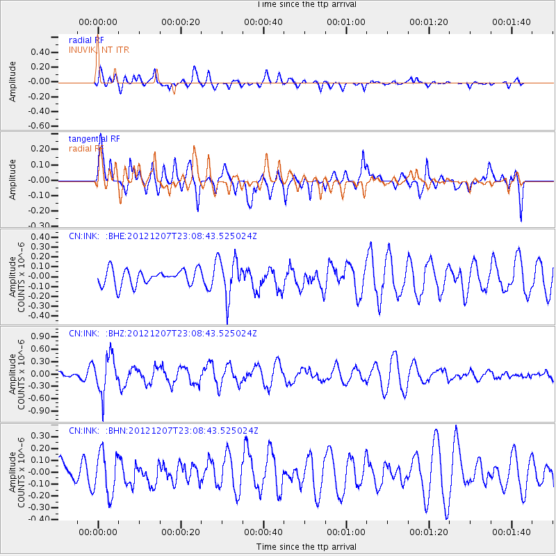
Signal To Noise
| Channel | StoN | STA | LTA |
| CN:INK: :BHZ:20121207T23:08:43.525024Z | 2.3359842 | 4.4733906E-7 | 1.9149917E-7 |
| CN:INK: :BHN:20121207T23:08:43.525024Z | 2.0257058 | 1.7766573E-7 | 8.770559E-8 |
| CN:INK: :BHE:20121207T23:08:43.525024Z | 2.4399192 | 1.9247814E-7 | 7.88871E-8 |
| Arrivals |
| Ps | |
| PpPs | |
| PsPs/PpSs | |


