You are here: Home > Network List > TA - USArray Transportable Network (new EarthScope stations) Stations List
> Station 147A Livingston, AL, USA > Earthquake Result Viewer
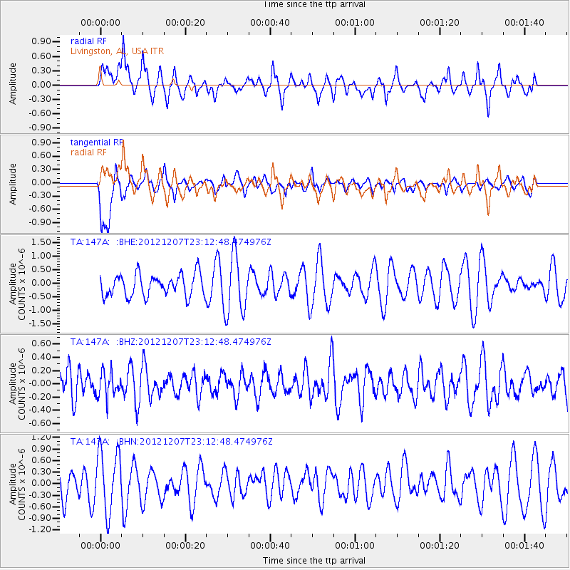
147A Livingston, AL, USA - Earthquake Result Viewer
*The percent match for this event was below the threshold and hence no stack was calculated.
| Earthquake location: |
Off East Coast Of Honshu, Japan |
| Earthquake latitude/longitude: |
37.7/143.8 |
| Earthquake time(UTC): |
2012/12/07 (342) 23:00:00 GMT |
| Earthquake Depth: |
24 km |
| Earthquake Magnitude: |
5.5 MB, 5.2 MW |
| Earthquake Catalog/Contributor: |
WHDF/NEIC |
|
| Network: |
TA USArray Transportable Network (new EarthScope stations) |
| Station: |
147A Livingston, AL, USA |
| Lat/Lon: |
32.67 N/88.27 W |
| Elevation: |
57 m |
|
| Distance: |
94.8 deg |
| Az: |
41.856 deg |
| Baz: |
321.155 deg |
| Ray Param: |
$rayparam |
*The percent match for this event was below the threshold and hence was not used in the summary stack. |
|
| Radial Match: |
53.790874 % |
| Radial Bump: |
400 |
| Transverse Match: |
56.711666 % |
| Transverse Bump: |
400 |
| SOD ConfigId: |
488671 |
| Insert Time: |
2013-03-29 05:49:35.092 +0000 |
| GWidth: |
2.5 |
| Max Bumps: |
400 |
| Tol: |
0.001 |
|
Signal To Noise
| Channel | StoN | STA | LTA |
| TA:147A: :BHZ:20121207T23:12:48.474976Z | 0.83728933 | 1.9132614E-7 | 2.285066E-7 |
| TA:147A: :BHN:20121207T23:12:48.474976Z | 1.9967618 | 8.029639E-7 | 4.0213305E-7 |
| TA:147A: :BHE:20121207T23:12:48.474976Z | 2.6954715 | 1.0812336E-6 | 4.0112965E-7 |
| Arrivals |
| Ps | |
| PpPs | |
| PsPs/PpSs | |


