You are here: Home > Network List > TA - USArray Transportable Network (new EarthScope stations) Stations List
> Station I42A Draeger Farm, Ripon, WI, USA > Earthquake Result Viewer
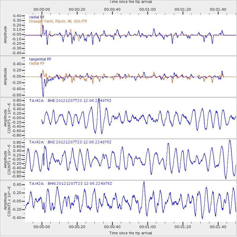
I42A Draeger Farm, Ripon, WI, USA - Earthquake Result Viewer
*The percent match for this event was below the threshold and hence no stack was calculated.
| Earthquake location: |
Off East Coast Of Honshu, Japan |
| Earthquake latitude/longitude: |
37.7/143.8 |
| Earthquake time(UTC): |
2012/12/07 (342) 23:00:00 GMT |
| Earthquake Depth: |
24 km |
| Earthquake Magnitude: |
5.5 MB, 5.2 MW |
| Earthquake Catalog/Contributor: |
WHDF/NEIC |
|
| Network: |
TA USArray Transportable Network (new EarthScope stations) |
| Station: |
I42A Draeger Farm, Ripon, WI, USA |
| Lat/Lon: |
43.89 N/88.91 W |
| Elevation: |
298 m |
|
| Distance: |
85.8 deg |
| Az: |
35.204 deg |
| Baz: |
320.791 deg |
| Ray Param: |
$rayparam |
*The percent match for this event was below the threshold and hence was not used in the summary stack. |
|
| Radial Match: |
62.18786 % |
| Radial Bump: |
400 |
| Transverse Match: |
79.2113 % |
| Transverse Bump: |
400 |
| SOD ConfigId: |
488671 |
| Insert Time: |
2013-03-29 05:50:57.831 +0000 |
| GWidth: |
2.5 |
| Max Bumps: |
400 |
| Tol: |
0.001 |
|
Signal To Noise
| Channel | StoN | STA | LTA |
| TA:I42A: :BHZ:20121207T23:12:06.224976Z | 1.1999341 | 3.8505766E-7 | 3.2089898E-7 |
| TA:I42A: :BHN:20121207T23:12:06.224976Z | 0.6303611 | 1.7180085E-7 | 2.7254356E-7 |
| TA:I42A: :BHE:20121207T23:12:06.224976Z | 2.8246763 | 5.5756567E-7 | 1.9739099E-7 |
| Arrivals |
| Ps | |
| PpPs | |
| PsPs/PpSs | |


