You are here: Home > Network List > TA - USArray Transportable Network (new EarthScope stations) Stations List
> Station N45A Kentland, IN, USA > Earthquake Result Viewer
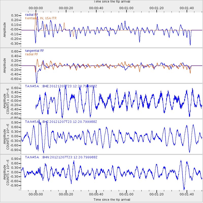
N45A Kentland, IN, USA - Earthquake Result Viewer
*The percent match for this event was below the threshold and hence no stack was calculated.
| Earthquake location: |
Off East Coast Of Honshu, Japan |
| Earthquake latitude/longitude: |
37.7/143.8 |
| Earthquake time(UTC): |
2012/12/07 (342) 23:00:00 GMT |
| Earthquake Depth: |
24 km |
| Earthquake Magnitude: |
5.5 MB, 5.2 MW |
| Earthquake Catalog/Contributor: |
WHDF/NEIC |
|
| Network: |
TA USArray Transportable Network (new EarthScope stations) |
| Station: |
N45A Kentland, IN, USA |
| Lat/Lon: |
40.85 N/87.51 W |
| Elevation: |
206 m |
|
| Distance: |
88.8 deg |
| Az: |
36.296 deg |
| Baz: |
321.784 deg |
| Ray Param: |
$rayparam |
*The percent match for this event was below the threshold and hence was not used in the summary stack. |
|
| Radial Match: |
35.22959 % |
| Radial Bump: |
400 |
| Transverse Match: |
74.466095 % |
| Transverse Bump: |
400 |
| SOD ConfigId: |
488671 |
| Insert Time: |
2013-03-29 05:51:00.798 +0000 |
| GWidth: |
2.5 |
| Max Bumps: |
400 |
| Tol: |
0.001 |
|
Signal To Noise
| Channel | StoN | STA | LTA |
| TA:N45A: :BHZ:20121207T23:12:20.799988Z | 2.4878707 | 6.853492E-7 | 2.7547622E-7 |
| TA:N45A: :BHN:20121207T23:12:20.799988Z | 0.72115606 | 1.9206239E-7 | 2.663257E-7 |
| TA:N45A: :BHE:20121207T23:12:20.799988Z | 1.3851528 | 4.581107E-7 | 3.3072936E-7 |
| Arrivals |
| Ps | |
| PpPs | |
| PsPs/PpSs | |


