You are here: Home > Network List > TA - USArray Transportable Network (new EarthScope stations) Stations List
> Station I46A Reed City, MI, USA > Earthquake Result Viewer
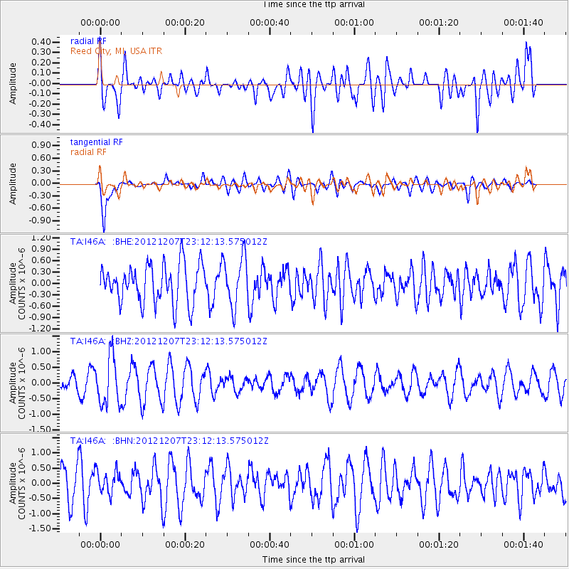
I46A Reed City, MI, USA - Earthquake Result Viewer
*The percent match for this event was below the threshold and hence no stack was calculated.
| Earthquake location: |
Off East Coast Of Honshu, Japan |
| Earthquake latitude/longitude: |
37.7/143.8 |
| Earthquake time(UTC): |
2012/12/07 (342) 23:00:00 GMT |
| Earthquake Depth: |
24 km |
| Earthquake Magnitude: |
5.5 MB, 5.2 MW |
| Earthquake Catalog/Contributor: |
WHDF/NEIC |
|
| Network: |
TA USArray Transportable Network (new EarthScope stations) |
| Station: |
I46A Reed City, MI, USA |
| Lat/Lon: |
43.94 N/85.45 W |
| Elevation: |
359 m |
|
| Distance: |
87.3 deg |
| Az: |
33.197 deg |
| Baz: |
323.066 deg |
| Ray Param: |
$rayparam |
*The percent match for this event was below the threshold and hence was not used in the summary stack. |
|
| Radial Match: |
52.594475 % |
| Radial Bump: |
400 |
| Transverse Match: |
76.31456 % |
| Transverse Bump: |
400 |
| SOD ConfigId: |
488671 |
| Insert Time: |
2013-03-29 05:52:54.624 +0000 |
| GWidth: |
2.5 |
| Max Bumps: |
400 |
| Tol: |
0.001 |
|
Signal To Noise
| Channel | StoN | STA | LTA |
| TA:I46A: :BHZ:20121207T23:12:13.575012Z | 2.0302274 | 7.7981366E-7 | 3.8410164E-7 |
| TA:I46A: :BHN:20121207T23:12:13.575012Z | 0.69143796 | 3.6768805E-7 | 5.31773E-7 |
| TA:I46A: :BHE:20121207T23:12:13.575012Z | 1.3077856 | 6.607897E-7 | 5.0527376E-7 |
| Arrivals |
| Ps | |
| PpPs | |
| PsPs/PpSs | |


