You are here: Home > Network List > UW - Pacific Northwest Regional Seismic Network Stations List
> Station PASS Maple Falls, WA, USA > Earthquake Result Viewer
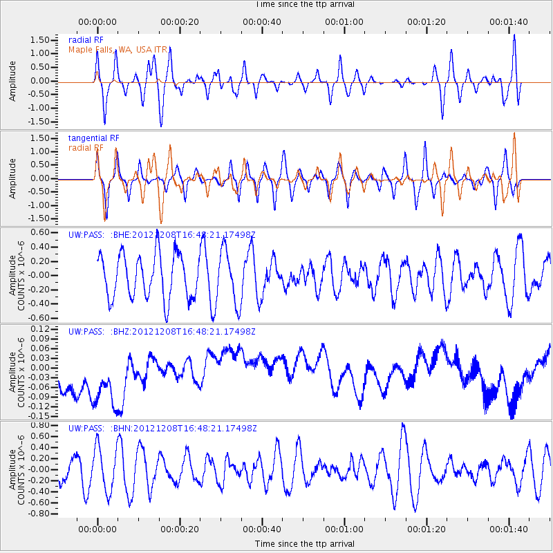
PASS Maple Falls, WA, USA - Earthquake Result Viewer
*The percent match for this event was below the threshold and hence no stack was calculated.
| Earthquake location: |
Near S Coast Of New Guinea, P.N.G. |
| Earthquake latitude/longitude: |
-7.2/144.0 |
| Earthquake time(UTC): |
2012/12/08 (343) 16:35:16 GMT |
| Earthquake Depth: |
10 km |
| Earthquake Magnitude: |
5.7 MB, 5.6 MS, 5.6 MW, 5.6 MW |
| Earthquake Catalog/Contributor: |
WHDF/NEIC |
|
| Network: |
UW Pacific Northwest Regional Seismic Network |
| Station: |
PASS Maple Falls, WA, USA |
| Lat/Lon: |
49.00 N/122.09 W |
| Elevation: |
174 m |
|
| Distance: |
98.0 deg |
| Az: |
41.563 deg |
| Baz: |
268.218 deg |
| Ray Param: |
$rayparam |
*The percent match for this event was below the threshold and hence was not used in the summary stack. |
|
| Radial Match: |
65.70206 % |
| Radial Bump: |
400 |
| Transverse Match: |
41.734814 % |
| Transverse Bump: |
400 |
| SOD ConfigId: |
488671 |
| Insert Time: |
2013-03-29 06:00:01.352 +0000 |
| GWidth: |
2.5 |
| Max Bumps: |
400 |
| Tol: |
0.001 |
|
Signal To Noise
| Channel | StoN | STA | LTA |
| UW:PASS: :BHZ:20121208T16:48:21.17498Z | 1.1343153 | 1.6625258E-7 | 1.4656648E-7 |
| UW:PASS: :BHN:20121208T16:48:21.17498Z | 1.4639153 | 4.1017765E-7 | 2.801922E-7 |
| UW:PASS: :BHE:20121208T16:48:21.17498Z | 1.2233331 | 3.7462087E-7 | 3.0622965E-7 |
| Arrivals |
| Ps | |
| PpPs | |
| PsPs/PpSs | |


