You are here: Home > Network List > AK - Alaska Regional Network Stations List
> Station GAMB Gambell Broadband > Earthquake Result Viewer
GAMB Gambell Broadband - Earthquake Result Viewer
| Earthquake location: |
Banda Sea |
| Earthquake latitude/longitude: |
-6.5/129.8 |
| Earthquake time(UTC): |
2012/12/10 (345) 16:53:08 GMT |
| Earthquake Depth: |
155 km |
| Earthquake Magnitude: |
6.6 MB, 7.1 MW, 7.1 MW |
| Earthquake Catalog/Contributor: |
WHDF/NEIC |
|
| Network: |
AK Alaska Regional Network |
| Station: |
GAMB Gambell Broadband |
| Lat/Lon: |
63.78 N/171.70 W |
| Elevation: |
10 m |
|
| Distance: |
82.6 deg |
| Az: |
22.452 deg |
| Baz: |
238.665 deg |
| Ray Param: |
0.04644469 |
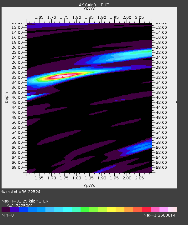
| Estimated Moho Depth: |
31.25 km |
| Estimated Crust Vp/Vs: |
1.74 |
| Assumed Crust Vp: |
6.24 km/s |
| Estimated Crust Vs: |
3.581 km/s |
| Estimated Crust Poisson's Ratio: |
0.25 |
|
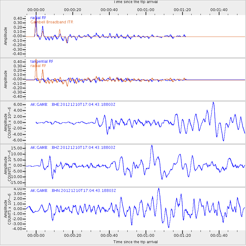
| Radial Match: |
96.32524 % |
| Radial Bump: |
312 |
| Transverse Match: |
77.43436 % |
| Transverse Bump: |
400 |
| SOD ConfigId: |
491031 |
| Insert Time: |
2013-04-02 15:01:03.512 +0000 |
| GWidth: |
2.5 |
| Max Bumps: |
400 |
| Tol: |
0.001 |
|
Signal To Noise
| Channel | StoN | STA | LTA |
| AK:GAMB: :BHZ:20121210T17:04:43.18803Z | 11.191178 | 2.2548638E-6 | 2.0148583E-7 |
| AK:GAMB: :BHN:20121210T17:04:43.18803Z | 2.369817 | 4.839169E-7 | 2.042001E-7 |
| AK:GAMB: :BHE:20121210T17:04:43.18803Z | 2.9372315 | 6.646299E-7 | 2.2627766E-7 |
| Arrivals |
| Ps | 3.8 SECOND |
| PpPs | 13 SECOND |
| PsPs/PpSs | 17 SECOND |


