You are here: Home > Network List > G - GEOSCOPE Stations List
> Station DZM Dzumac, New Caledonia > Earthquake Result Viewer
DZM Dzumac, New Caledonia - Earthquake Result Viewer
| Earthquake location: |
Banda Sea |
| Earthquake latitude/longitude: |
-6.5/129.8 |
| Earthquake time(UTC): |
2012/12/10 (345) 16:53:08 GMT |
| Earthquake Depth: |
155 km |
| Earthquake Magnitude: |
6.6 MB, 7.1 MW, 7.1 MW |
| Earthquake Catalog/Contributor: |
WHDF/NEIC |
|
| Network: |
G GEOSCOPE |
| Station: |
DZM Dzumac, New Caledonia |
| Lat/Lon: |
22.07 S/166.44 E |
| Elevation: |
878 m |
|
| Distance: |
38.6 deg |
| Az: |
117.421 deg |
| Baz: |
288.046 deg |
| Ray Param: |
0.07493118 |
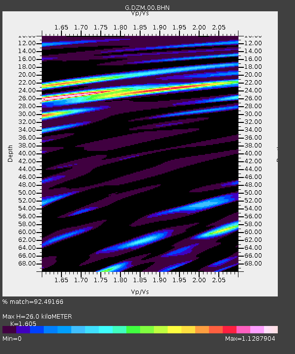
| Estimated Moho Depth: |
26.0 km |
| Estimated Crust Vp/Vs: |
1.61 |
| Assumed Crust Vp: |
5.14 km/s |
| Estimated Crust Vs: |
3.202 km/s |
| Estimated Crust Poisson's Ratio: |
0.18 |
|
| Radial Match: |
92.49166 % |
| Radial Bump: |
359 |
| Transverse Match: |
84.61007 % |
| Transverse Bump: |
400 |
| SOD ConfigId: |
491031 |
| Insert Time: |
2013-04-02 15:02:29.724 +0000 |
| GWidth: |
2.5 |
| Max Bumps: |
400 |
| Tol: |
0.001 |
|
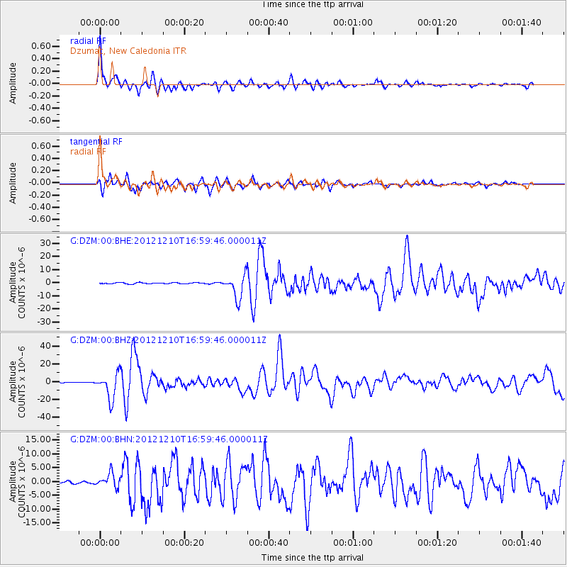
Signal To Noise
| Channel | StoN | STA | LTA |
| G:DZM:00:BHZ:20121210T16:59:46.000011Z | 32.64194 | 1.4947535E-5 | 4.5792424E-7 |
| G:DZM:00:BHN:20121210T16:59:46.000011Z | 6.093204 | 2.6260518E-6 | 4.3098046E-7 |
| G:DZM:00:BHE:20121210T16:59:46.000011Z | 20.789557 | 9.253859E-6 | 4.4512055E-7 |
| Arrivals |
| Ps | 3.2 SECOND |
| PpPs | 13 SECOND |
| PsPs/PpSs | 16 SECOND |


