You are here: Home > Network List > IC - New China Digital Seismograph Network Stations List
> Station MDJ Mudanjiang, Heilongjiang Province, China > Earthquake Result Viewer
MDJ Mudanjiang, Heilongjiang Province, China - Earthquake Result Viewer
| Earthquake location: |
Banda Sea |
| Earthquake latitude/longitude: |
-6.5/129.8 |
| Earthquake time(UTC): |
2012/12/10 (345) 16:53:08 GMT |
| Earthquake Depth: |
155 km |
| Earthquake Magnitude: |
6.6 MB, 7.1 MW, 7.1 MW |
| Earthquake Catalog/Contributor: |
WHDF/NEIC |
|
| Network: |
IC New China Digital Seismograph Network |
| Station: |
MDJ Mudanjiang, Heilongjiang Province, China |
| Lat/Lon: |
44.62 N/129.59 E |
| Elevation: |
270 m |
|
| Distance: |
50.9 deg |
| Az: |
359.785 deg |
| Baz: |
179.7 deg |
| Ray Param: |
0.06721529 |
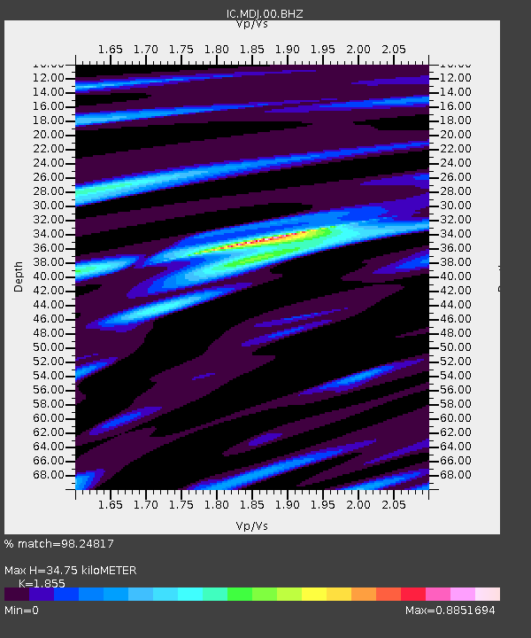
| Estimated Moho Depth: |
34.75 km |
| Estimated Crust Vp/Vs: |
1.86 |
| Assumed Crust Vp: |
6.459 km/s |
| Estimated Crust Vs: |
3.482 km/s |
| Estimated Crust Poisson's Ratio: |
0.30 |
|
| Radial Match: |
98.24817 % |
| Radial Bump: |
254 |
| Transverse Match: |
92.3377 % |
| Transverse Bump: |
400 |
| SOD ConfigId: |
491031 |
| Insert Time: |
2013-04-02 15:02:45.269 +0000 |
| GWidth: |
2.5 |
| Max Bumps: |
400 |
| Tol: |
0.001 |
|
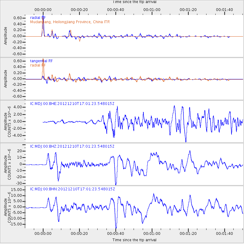
Signal To Noise
| Channel | StoN | STA | LTA |
| IC:MDJ:00:BHZ:20121210T17:01:23.548015Z | 20.801311 | 6.7459646E-6 | 3.2430475E-7 |
| IC:MDJ:00:BHN:20121210T17:01:23.548015Z | 10.820931 | 3.2265045E-6 | 2.9817255E-7 |
| IC:MDJ:00:BHE:20121210T17:01:23.548015Z | 4.6408367 | 8.7104064E-7 | 1.8769043E-7 |
| Arrivals |
| Ps | 4.9 SECOND |
| PpPs | 15 SECOND |
| PsPs/PpSs | 19 SECOND |


