You are here: Home > Network List > ND - New CaleDonia Broadband Seismic Network Stations List
> Station MARNC Mare, Loyalty islands, New Caledonia > Earthquake Result Viewer
MARNC Mare, Loyalty islands, New Caledonia - Earthquake Result Viewer
| Earthquake location: |
Banda Sea |
| Earthquake latitude/longitude: |
-6.5/129.8 |
| Earthquake time(UTC): |
2012/12/10 (345) 16:53:08 GMT |
| Earthquake Depth: |
155 km |
| Earthquake Magnitude: |
6.6 MB, 7.1 MW, 7.1 MW |
| Earthquake Catalog/Contributor: |
WHDF/NEIC |
|
| Network: |
ND New CaleDonia Broadband Seismic Network |
| Station: |
MARNC Mare, Loyalty islands, New Caledonia |
| Lat/Lon: |
21.48 S/168.03 E |
| Elevation: |
44 m |
|
| Distance: |
39.8 deg |
| Az: |
115.844 deg |
| Baz: |
286.238 deg |
| Ray Param: |
0.0742163 |
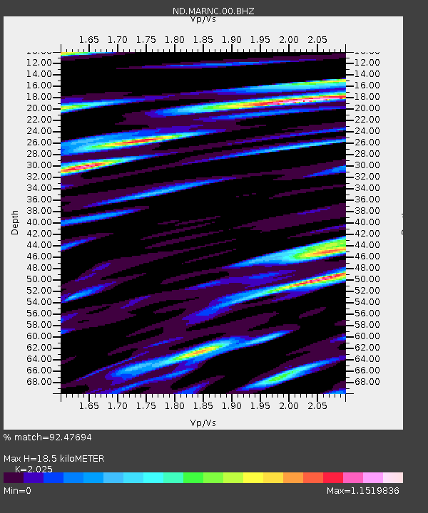
| Estimated Moho Depth: |
18.5 km |
| Estimated Crust Vp/Vs: |
2.03 |
| Assumed Crust Vp: |
4.082 km/s |
| Estimated Crust Vs: |
2.016 km/s |
| Estimated Crust Poisson's Ratio: |
0.34 |
|
| Radial Match: |
92.47694 % |
| Radial Bump: |
400 |
| Transverse Match: |
80.07996 % |
| Transverse Bump: |
400 |
| SOD ConfigId: |
491031 |
| Insert Time: |
2013-04-02 15:04:25.073 +0000 |
| GWidth: |
2.5 |
| Max Bumps: |
400 |
| Tol: |
0.001 |
|
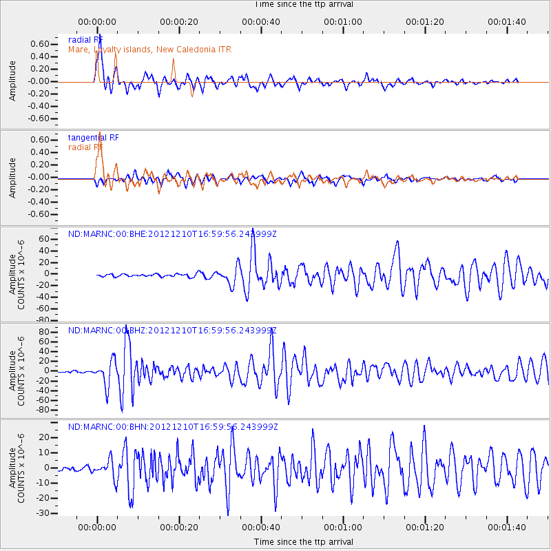
Signal To Noise
| Channel | StoN | STA | LTA |
| ND:MARNC:00:BHZ:20121210T16:59:56.243999Z | 19.929834 | 2.5834073E-5 | 1.2962513E-6 |
| ND:MARNC:00:BHN:20121210T16:59:56.243999Z | 4.4562697 | 6.165516E-6 | 1.38356E-6 |
| ND:MARNC:00:BHE:20121210T16:59:56.243999Z | 6.6847124 | 1.5755124E-5 | 2.3568887E-6 |
| Arrivals |
| Ps | 4.8 SECOND |
| PpPs | 13 SECOND |
| PsPs/PpSs | 18 SECOND |


