You are here: Home > Network List > CZ - Czech Regional Seismic Network Stations List
> Station KHC CZ.KHC > Earthquake Result Viewer
KHC CZ.KHC - Earthquake Result Viewer
| Earthquake location: |
East Of Kuril Islands |
| Earthquake latitude/longitude: |
46.2/154.5 |
| Earthquake time(UTC): |
2007/01/13 (013) 04:23:21 GMT |
| Earthquake Depth: |
10 km |
| Earthquake Magnitude: |
7.3 MB, 8.2 MS, 8.1 MW, 7.9 MW |
| Earthquake Catalog/Contributor: |
WHDF/NEIC |
|
| Network: |
CZ Czech Regional Seismic Network |
| Station: |
KHC CZ.KHC |
| Lat/Lon: |
49.13 N/13.58 E |
| Elevation: |
700 m |
|
| Distance: |
79.1 deg |
| Az: |
335.075 deg |
| Baz: |
26.442 deg |
| Ray Param: |
0.049183317 |
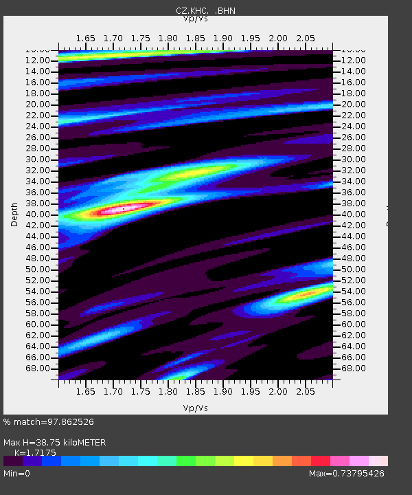
| Estimated Moho Depth: |
38.75 km |
| Estimated Crust Vp/Vs: |
1.72 |
| Assumed Crust Vp: |
6.276 km/s |
| Estimated Crust Vs: |
3.654 km/s |
| Estimated Crust Poisson's Ratio: |
0.24 |
|
| Radial Match: |
97.862526 % |
| Radial Bump: |
400 |
| Transverse Match: |
92.27904 % |
| Transverse Bump: |
400 |
| SOD ConfigId: |
2564 |
| Insert Time: |
2010-02-27 01:24:51.838 +0000 |
| GWidth: |
2.5 |
| Max Bumps: |
400 |
| Tol: |
0.001 |
|

Signal To Noise
| Channel | StoN | STA | LTA |
| CZ:KHC: :BHN:20070113T04:34:54.394009Z | 3.8196163 | 6.418056E-6 | 1.680288E-6 |
| CZ:KHC: :BHE:20070113T04:34:54.394009Z | 3.009034 | 3.7763034E-6 | 1.2549885E-6 |
| CZ:KHC: :BHZ:20070113T04:34:54.394009Z | 6.483069 | 1.780561E-5 | 2.746479E-6 |
| Arrivals |
| Ps | 4.6 SECOND |
| PpPs | 16 SECOND |
| PsPs/PpSs | 21 SECOND |


