You are here: Home > Network List > UW - Pacific Northwest Regional Seismic Network Stations List
> Station LEBA Lebam, WA, USA > Earthquake Result Viewer
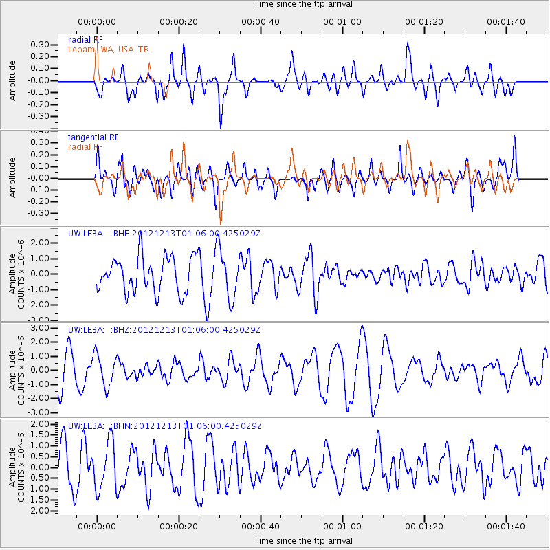
LEBA Lebam, WA, USA - Earthquake Result Viewer
*The percent match for this event was below the threshold and hence no stack was calculated.
| Earthquake location: |
Kermadec Islands, New Zealand |
| Earthquake latitude/longitude: |
-30.9/-178.4 |
| Earthquake time(UTC): |
2012/12/13 (348) 00:53:28 GMT |
| Earthquake Depth: |
39 km |
| Earthquake Magnitude: |
5.5 MB, 4.9 MS, 5.3 MW, 5.4 MW |
| Earthquake Catalog/Contributor: |
WHDF/NEIC |
|
| Network: |
UW Pacific Northwest Regional Seismic Network |
| Station: |
LEBA Lebam, WA, USA |
| Lat/Lon: |
46.55 N/123.56 W |
| Elevation: |
73 m |
|
| Distance: |
91.6 deg |
| Az: |
34.361 deg |
| Baz: |
224.655 deg |
| Ray Param: |
$rayparam |
*The percent match for this event was below the threshold and hence was not used in the summary stack. |
|
| Radial Match: |
44.562588 % |
| Radial Bump: |
400 |
| Transverse Match: |
51.32871 % |
| Transverse Bump: |
400 |
| SOD ConfigId: |
491031 |
| Insert Time: |
2013-04-02 15:17:17.768 +0000 |
| GWidth: |
2.5 |
| Max Bumps: |
400 |
| Tol: |
0.001 |
|
Signal To Noise
| Channel | StoN | STA | LTA |
| UW:LEBA: :BHZ:20121213T01:06:00.425029Z | 1.186519 | 1.1286546E-6 | 9.5123175E-7 |
| UW:LEBA: :BHN:20121213T01:06:00.425029Z | 1.1495044 | 1.1351864E-6 | 9.875442E-7 |
| UW:LEBA: :BHE:20121213T01:06:00.425029Z | 1.4407237 | 1.611759E-6 | 1.1187149E-6 |
| Arrivals |
| Ps | |
| PpPs | |
| PsPs/PpSs | |


