You are here: Home > Network List > CI - Caltech Regional Seismic Network Stations List
> Station FMP Fort MacArthur Park, Pt. Fermin San Pedro, CA, USA > Earthquake Result Viewer
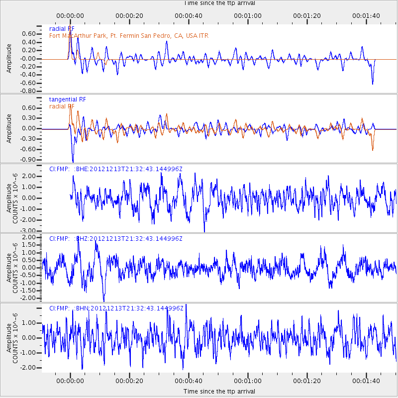
FMP Fort MacArthur Park, Pt. Fermin San Pedro, CA, USA - Earthquake Result Viewer
*The percent match for this event was below the threshold and hence no stack was calculated.
| Earthquake location: |
El Salvador |
| Earthquake latitude/longitude: |
13.1/-90.0 |
| Earthquake time(UTC): |
2012/12/13 (348) 21:26:39 GMT |
| Earthquake Depth: |
10 km |
| Earthquake Magnitude: |
5.5 MB, 4.9 MS, 5.3 MW, 5.5 MW |
| Earthquake Catalog/Contributor: |
WHDF/NEIC |
|
| Network: |
CI Caltech Regional Seismic Network |
| Station: |
FMP Fort MacArthur Park, Pt. Fermin San Pedro, CA, USA |
| Lat/Lon: |
33.71 N/118.29 W |
| Elevation: |
89 m |
|
| Distance: |
33.0 deg |
| Az: |
313.355 deg |
| Baz: |
121.788 deg |
| Ray Param: |
$rayparam |
*The percent match for this event was below the threshold and hence was not used in the summary stack. |
|
| Radial Match: |
65.136665 % |
| Radial Bump: |
400 |
| Transverse Match: |
74.95924 % |
| Transverse Bump: |
400 |
| SOD ConfigId: |
491031 |
| Insert Time: |
2013-04-02 15:22:42.235 +0000 |
| GWidth: |
2.5 |
| Max Bumps: |
400 |
| Tol: |
0.001 |
|
Signal To Noise
| Channel | StoN | STA | LTA |
| CI:FMP: :BHZ:20121213T21:32:43.144996Z | 2.432372 | 8.7768325E-7 | 3.608343E-7 |
| CI:FMP: :BHN:20121213T21:32:43.144996Z | 1.3381563 | 8.666825E-7 | 6.476691E-7 |
| CI:FMP: :BHE:20121213T21:32:43.144996Z | 1.2717181 | 1.0160431E-6 | 7.989531E-7 |
| Arrivals |
| Ps | |
| PpPs | |
| PsPs/PpSs | |


