You are here: Home > Network List > CI - Caltech Regional Seismic Network Stations List
> Station MPP McPhearson Peak > Earthquake Result Viewer
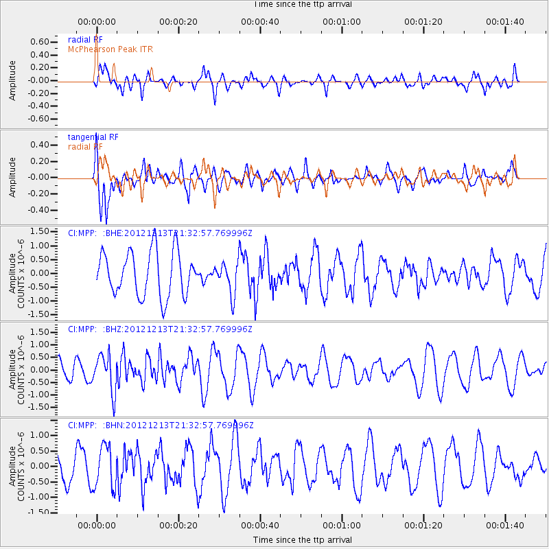
MPP McPhearson Peak - Earthquake Result Viewer
*The percent match for this event was below the threshold and hence no stack was calculated.
| Earthquake location: |
El Salvador |
| Earthquake latitude/longitude: |
13.1/-90.0 |
| Earthquake time(UTC): |
2012/12/13 (348) 21:26:39 GMT |
| Earthquake Depth: |
10 km |
| Earthquake Magnitude: |
5.5 MB, 4.9 MS, 5.3 MW, 5.5 MW |
| Earthquake Catalog/Contributor: |
WHDF/NEIC |
|
| Network: |
CI Caltech Regional Seismic Network |
| Station: |
MPP McPhearson Peak |
| Lat/Lon: |
34.89 N/119.81 W |
| Elevation: |
1739 m |
|
| Distance: |
34.6 deg |
| Az: |
313.965 deg |
| Baz: |
121.442 deg |
| Ray Param: |
$rayparam |
*The percent match for this event was below the threshold and hence was not used in the summary stack. |
|
| Radial Match: |
64.1063 % |
| Radial Bump: |
400 |
| Transverse Match: |
62.216408 % |
| Transverse Bump: |
400 |
| SOD ConfigId: |
491031 |
| Insert Time: |
2013-04-02 15:22:46.507 +0000 |
| GWidth: |
2.5 |
| Max Bumps: |
400 |
| Tol: |
0.001 |
|
Signal To Noise
| Channel | StoN | STA | LTA |
| CI:MPP: :BHZ:20121213T21:32:57.769996Z | 2.1749747 | 7.4380625E-7 | 3.4198388E-7 |
| CI:MPP: :BHN:20121213T21:32:57.769996Z | 1.2277784 | 6.830876E-7 | 5.5636065E-7 |
| CI:MPP: :BHE:20121213T21:32:57.769996Z | 0.755479 | 6.065459E-7 | 8.0286264E-7 |
| Arrivals |
| Ps | |
| PpPs | |
| PsPs/PpSs | |


