You are here: Home > Network List > TA - USArray Transportable Network (new EarthScope stations) Stations List
> Station J41A Loganville, WI, USA > Earthquake Result Viewer
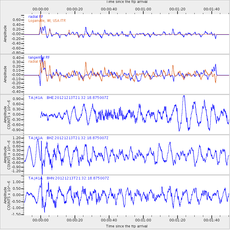
J41A Loganville, WI, USA - Earthquake Result Viewer
*The percent match for this event was below the threshold and hence no stack was calculated.
| Earthquake location: |
El Salvador |
| Earthquake latitude/longitude: |
13.1/-90.0 |
| Earthquake time(UTC): |
2012/12/13 (348) 21:26:39 GMT |
| Earthquake Depth: |
10 km |
| Earthquake Magnitude: |
5.5 MB, 4.9 MS, 5.3 MW, 5.5 MW |
| Earthquake Catalog/Contributor: |
WHDF/NEIC |
|
| Network: |
TA USArray Transportable Network (new EarthScope stations) |
| Station: |
J41A Loganville, WI, USA |
| Lat/Lon: |
43.37 N/90.01 W |
| Elevation: |
360 m |
|
| Distance: |
30.2 deg |
| Az: |
359.932 deg |
| Baz: |
179.91 deg |
| Ray Param: |
$rayparam |
*The percent match for this event was below the threshold and hence was not used in the summary stack. |
|
| Radial Match: |
58.7339 % |
| Radial Bump: |
400 |
| Transverse Match: |
70.48771 % |
| Transverse Bump: |
400 |
| SOD ConfigId: |
491031 |
| Insert Time: |
2013-04-02 15:26:30.853 +0000 |
| GWidth: |
2.5 |
| Max Bumps: |
400 |
| Tol: |
0.001 |
|
Signal To Noise
| Channel | StoN | STA | LTA |
| TA:J41A: :BHZ:20121213T21:32:18.875007Z | 2.1496782 | 5.7927156E-7 | 2.6946896E-7 |
| TA:J41A: :BHN:20121213T21:32:18.875007Z | 2.7767682 | 7.2040706E-7 | 2.5944084E-7 |
| TA:J41A: :BHE:20121213T21:32:18.875007Z | 1.5290197 | 2.9622808E-7 | 1.9373725E-7 |
| Arrivals |
| Ps | |
| PpPs | |
| PsPs/PpSs | |


