You are here: Home > Network List > TA - USArray Transportable Network (new EarthScope stations) Stations List
> Station F39A Loretta, WI, USA > Earthquake Result Viewer
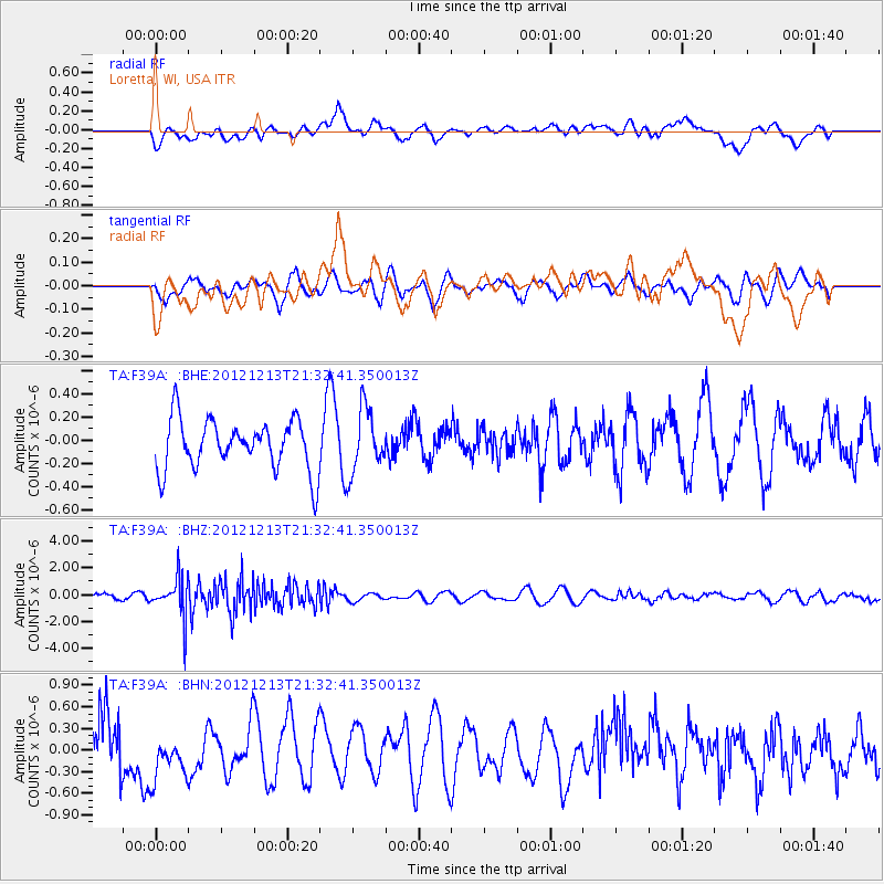
F39A Loretta, WI, USA - Earthquake Result Viewer
*The percent match for this event was below the threshold and hence no stack was calculated.
| Earthquake location: |
El Salvador |
| Earthquake latitude/longitude: |
13.1/-90.0 |
| Earthquake time(UTC): |
2012/12/13 (348) 21:26:39 GMT |
| Earthquake Depth: |
10 km |
| Earthquake Magnitude: |
5.5 MB, 4.9 MS, 5.3 MW, 5.5 MW |
| Earthquake Catalog/Contributor: |
WHDF/NEIC |
|
| Network: |
TA USArray Transportable Network (new EarthScope stations) |
| Station: |
F39A Loretta, WI, USA |
| Lat/Lon: |
45.92 N/90.92 W |
| Elevation: |
440 m |
|
| Distance: |
32.7 deg |
| Az: |
358.771 deg |
| Baz: |
178.285 deg |
| Ray Param: |
$rayparam |
*The percent match for this event was below the threshold and hence was not used in the summary stack. |
|
| Radial Match: |
55.816074 % |
| Radial Bump: |
400 |
| Transverse Match: |
43.31175 % |
| Transverse Bump: |
365 |
| SOD ConfigId: |
491031 |
| Insert Time: |
2013-04-02 15:26:54.117 +0000 |
| GWidth: |
2.5 |
| Max Bumps: |
400 |
| Tol: |
0.001 |
|
Signal To Noise
| Channel | StoN | STA | LTA |
| TA:F39A: :BHZ:20121213T21:32:41.350013Z | 4.637106 | 1.4820172E-6 | 3.195996E-7 |
| TA:F39A: :BHN:20121213T21:32:41.350013Z | 1.0685812 | 4.0921623E-7 | 3.8295283E-7 |
| TA:F39A: :BHE:20121213T21:32:41.350013Z | 1.2632594 | 2.7370012E-7 | 2.1666186E-7 |
| Arrivals |
| Ps | |
| PpPs | |
| PsPs/PpSs | |


