You are here: Home > Network List > TA - USArray Transportable Network (new EarthScope stations) Stations List
> Station I45A Fountain, MI, USA > Earthquake Result Viewer
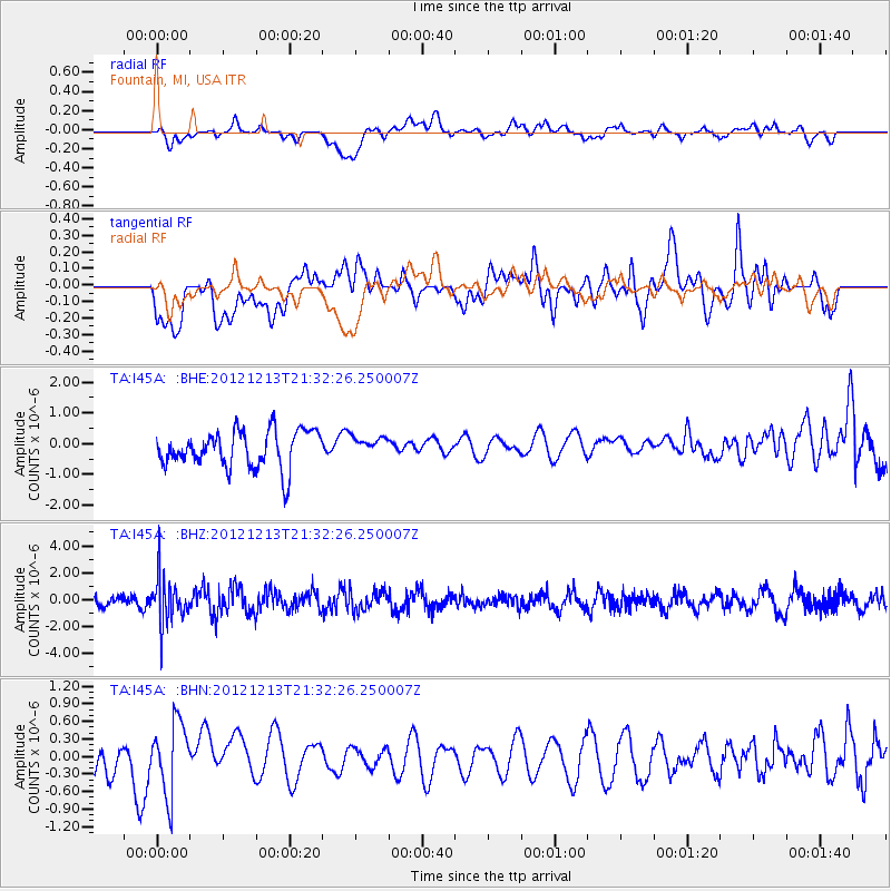
I45A Fountain, MI, USA - Earthquake Result Viewer
*The percent match for this event was below the threshold and hence no stack was calculated.
| Earthquake location: |
El Salvador |
| Earthquake latitude/longitude: |
13.1/-90.0 |
| Earthquake time(UTC): |
2012/12/13 (348) 21:26:39 GMT |
| Earthquake Depth: |
10 km |
| Earthquake Magnitude: |
5.5 MB, 4.9 MS, 5.3 MW, 5.5 MW |
| Earthquake Catalog/Contributor: |
WHDF/NEIC |
|
| Network: |
TA USArray Transportable Network (new EarthScope stations) |
| Station: |
I45A Fountain, MI, USA |
| Lat/Lon: |
44.04 N/86.23 W |
| Elevation: |
215 m |
|
| Distance: |
31.0 deg |
| Az: |
5.226 deg |
| Baz: |
187.069 deg |
| Ray Param: |
$rayparam |
*The percent match for this event was below the threshold and hence was not used in the summary stack. |
|
| Radial Match: |
57.680187 % |
| Radial Bump: |
400 |
| Transverse Match: |
50.26567 % |
| Transverse Bump: |
400 |
| SOD ConfigId: |
491031 |
| Insert Time: |
2013-04-02 15:28:09.512 +0000 |
| GWidth: |
2.5 |
| Max Bumps: |
400 |
| Tol: |
0.001 |
|
Signal To Noise
| Channel | StoN | STA | LTA |
| TA:I45A: :BHZ:20121213T21:32:26.250007Z | 4.20623 | 1.7172325E-6 | 4.0825927E-7 |
| TA:I45A: :BHN:20121213T21:32:26.250007Z | 2.3673012 | 6.3389865E-7 | 2.6777272E-7 |
| TA:I45A: :BHE:20121213T21:32:26.250007Z | 0.52121663 | 3.1328858E-7 | 6.0107175E-7 |
| Arrivals |
| Ps | |
| PpPs | |
| PsPs/PpSs | |


