You are here: Home > Network List > TA - USArray Transportable Network (new EarthScope stations) Stations List
> Station R11A Troy Canyon, Currant, NV, USA > Earthquake Result Viewer
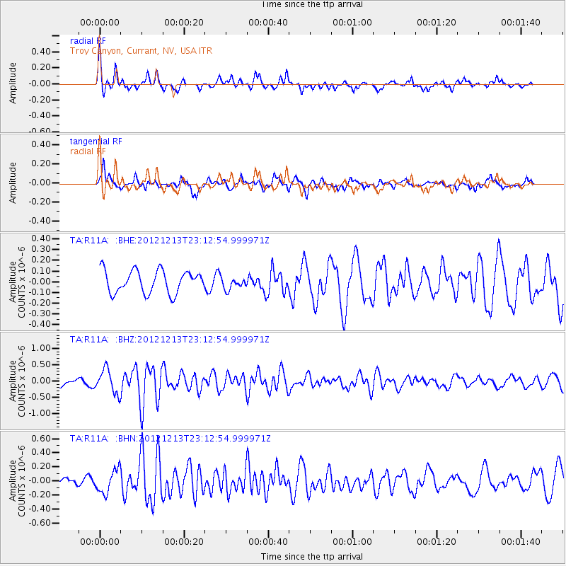
R11A Troy Canyon, Currant, NV, USA - Earthquake Result Viewer
*The percent match for this event was below the threshold and hence no stack was calculated.
| Earthquake location: |
East Of Severnaya Zemlya |
| Earthquake latitude/longitude: |
80.8/121.4 |
| Earthquake time(UTC): |
2012/12/13 (348) 23:03:38 GMT |
| Earthquake Depth: |
10 km |
| Earthquake Magnitude: |
5.7 MB, 5.1 MS, 5.5 MW, 5.6 MW |
| Earthquake Catalog/Contributor: |
WHDF/NEIC |
|
| Network: |
TA USArray Transportable Network (new EarthScope stations) |
| Station: |
R11A Troy Canyon, Currant, NV, USA |
| Lat/Lon: |
38.35 N/115.59 W |
| Elevation: |
1756 m |
|
| Distance: |
57.3 deg |
| Az: |
51.603 deg |
| Baz: |
350.773 deg |
| Ray Param: |
$rayparam |
*The percent match for this event was below the threshold and hence was not used in the summary stack. |
|
| Radial Match: |
76.364105 % |
| Radial Bump: |
398 |
| Transverse Match: |
62.578526 % |
| Transverse Bump: |
400 |
| SOD ConfigId: |
491031 |
| Insert Time: |
2013-04-02 15:38:33.569 +0000 |
| GWidth: |
2.5 |
| Max Bumps: |
400 |
| Tol: |
0.001 |
|
Signal To Noise
| Channel | StoN | STA | LTA |
| TA:R11A: :BHZ:20121213T23:12:54.999971Z | 2.99599 | 3.7072937E-7 | 1.2374186E-7 |
| TA:R11A: :BHN:20121213T23:12:54.999971Z | 2.033025 | 1.6910789E-7 | 8.318043E-8 |
| TA:R11A: :BHE:20121213T23:12:54.999971Z | 0.54699343 | 5.693102E-8 | 1.040799E-7 |
| Arrivals |
| Ps | |
| PpPs | |
| PsPs/PpSs | |


