You are here: Home > Network List > CZ - Czech Regional Seismic Network Stations List
> Station KHC CZ.KHC > Earthquake Result Viewer
KHC CZ.KHC - Earthquake Result Viewer
| Earthquake location: |
North Of Honduras |
| Earthquake latitude/longitude: |
16.7/-86.2 |
| Earthquake time(UTC): |
2009/05/28 (148) 08:24:45 GMT |
| Earthquake Depth: |
10 km |
| Earthquake Magnitude: |
6.7 MB, 7.2 MS, 7.3 MW, 7.3 MW |
| Earthquake Catalog/Contributor: |
WHDF/NEIC |
|
| Network: |
CZ Czech Regional Seismic Network |
| Station: |
KHC CZ.KHC |
| Lat/Lon: |
49.13 N/13.58 E |
| Elevation: |
700 m |
|
| Distance: |
83.8 deg |
| Az: |
40.622 deg |
| Baz: |
288.226 deg |
| Ray Param: |
0.04594441 |
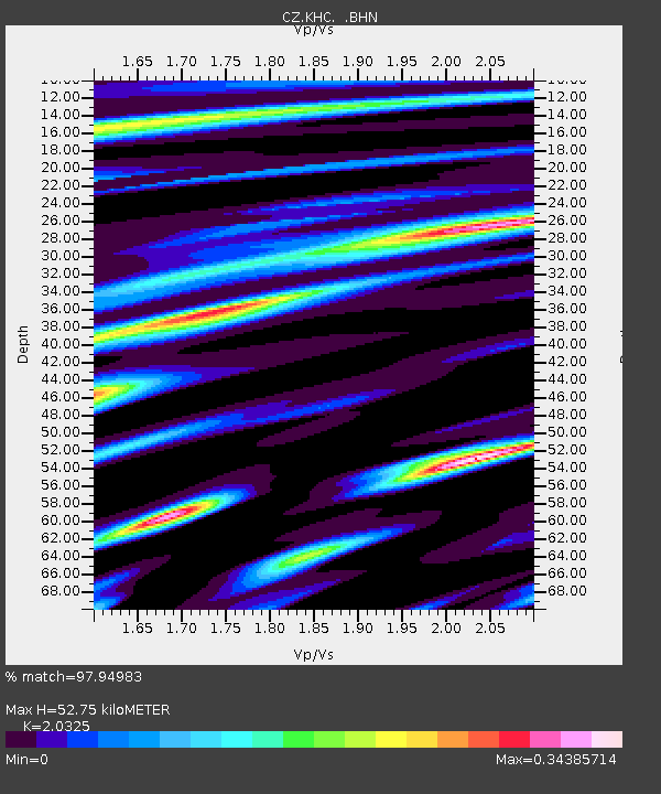
| Estimated Moho Depth: |
52.75 km |
| Estimated Crust Vp/Vs: |
2.03 |
| Assumed Crust Vp: |
6.276 km/s |
| Estimated Crust Vs: |
3.088 km/s |
| Estimated Crust Poisson's Ratio: |
0.34 |
|
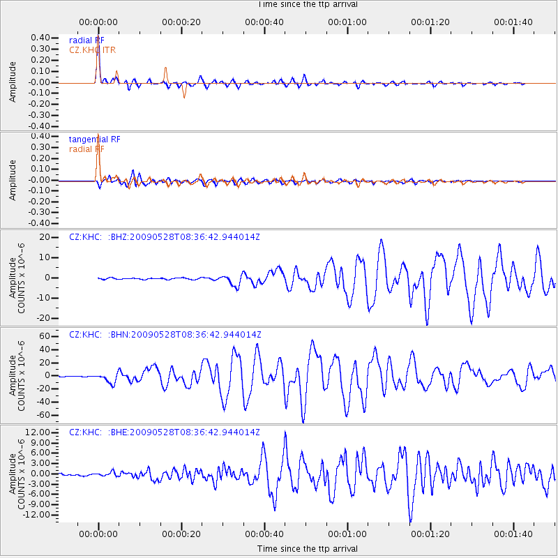
| Radial Match: |
97.94983 % |
| Radial Bump: |
297 |
| Transverse Match: |
92.40126 % |
| Transverse Bump: |
400 |
| SOD ConfigId: |
2648 |
| Insert Time: |
2010-02-27 01:25:28.301 +0000 |
| GWidth: |
2.5 |
| Max Bumps: |
400 |
| Tol: |
0.001 |
|
Signal To Noise
| Channel | StoN | STA | LTA |
| CZ:KHC: :BHN:20090528T08:36:42.944014Z | 19.380262 | 7.766802E-6 | 4.0075835E-7 |
| CZ:KHC: :BHE:20090528T08:36:42.944014Z | 1.6566327 | 6.198213E-7 | 3.741453E-7 |
| CZ:KHC: :BHZ:20090528T08:36:42.944014Z | 8.180739 | 2.7804897E-6 | 3.3988246E-7 |
| Arrivals |
| Ps | 8.9 SECOND |
| PpPs | 25 SECOND |
| PsPs/PpSs | 34 SECOND |


