You are here: Home > Network List > TA - USArray Transportable Network (new EarthScope stations) Stations List
> Station W41B Gary Mavity, Velonia, AR, USA > Earthquake Result Viewer
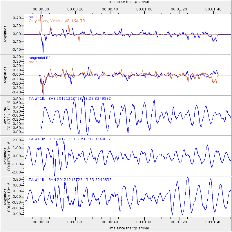
W41B Gary Mavity, Velonia, AR, USA - Earthquake Result Viewer
*The percent match for this event was below the threshold and hence no stack was calculated.
| Earthquake location: |
East Of Severnaya Zemlya |
| Earthquake latitude/longitude: |
80.8/121.4 |
| Earthquake time(UTC): |
2012/12/13 (348) 23:03:38 GMT |
| Earthquake Depth: |
10 km |
| Earthquake Magnitude: |
5.7 MB, 5.1 MS, 5.5 MW, 5.6 MW |
| Earthquake Catalog/Contributor: |
WHDF/NEIC |
|
| Network: |
TA USArray Transportable Network (new EarthScope stations) |
| Station: |
W41B Gary Mavity, Velonia, AR, USA |
| Lat/Lon: |
35.17 N/92.25 W |
| Elevation: |
95 m |
|
| Distance: |
62.9 deg |
| Az: |
30.657 deg |
| Baz: |
354.254 deg |
| Ray Param: |
$rayparam |
*The percent match for this event was below the threshold and hence was not used in the summary stack. |
|
| Radial Match: |
69.507935 % |
| Radial Bump: |
400 |
| Transverse Match: |
68.89042 % |
| Transverse Bump: |
400 |
| SOD ConfigId: |
491031 |
| Insert Time: |
2013-04-02 15:39:48.949 +0000 |
| GWidth: |
2.5 |
| Max Bumps: |
400 |
| Tol: |
0.001 |
|
Signal To Noise
| Channel | StoN | STA | LTA |
| TA:W41B: :BHZ:20121213T23:13:33.324983Z | 1.5884343 | 9.4159884E-7 | 5.9278426E-7 |
| TA:W41B: :BHN:20121213T23:13:33.324983Z | 0.78029484 | 2.3963983E-7 | 3.0711445E-7 |
| TA:W41B: :BHE:20121213T23:13:33.324983Z | 0.70236707 | 2.8897384E-7 | 4.114285E-7 |
| Arrivals |
| Ps | |
| PpPs | |
| PsPs/PpSs | |


