You are here: Home > Network List > TA - USArray Transportable Network (new EarthScope stations) Stations List
> Station H38A Maiden Rock, WI, USA > Earthquake Result Viewer
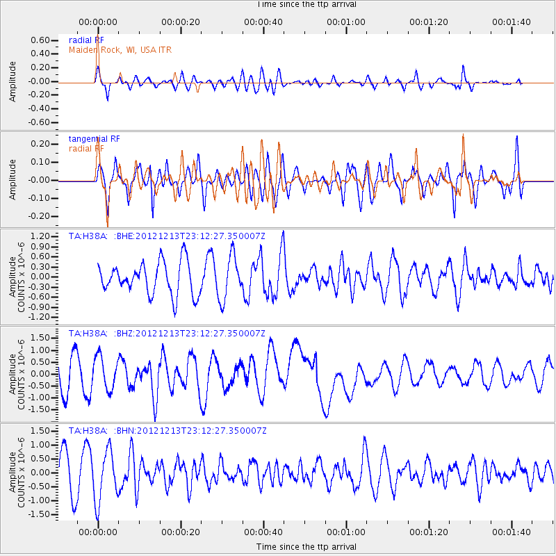
H38A Maiden Rock, WI, USA - Earthquake Result Viewer
*The percent match for this event was below the threshold and hence no stack was calculated.
| Earthquake location: |
East Of Severnaya Zemlya |
| Earthquake latitude/longitude: |
80.8/121.4 |
| Earthquake time(UTC): |
2012/12/13 (348) 23:03:38 GMT |
| Earthquake Depth: |
10 km |
| Earthquake Magnitude: |
5.7 MB, 5.1 MS, 5.5 MW, 5.6 MW |
| Earthquake Catalog/Contributor: |
WHDF/NEIC |
|
| Network: |
TA USArray Transportable Network (new EarthScope stations) |
| Station: |
H38A Maiden Rock, WI, USA |
| Lat/Lon: |
44.68 N/92.28 W |
| Elevation: |
333 m |
|
| Distance: |
53.4 deg |
| Az: |
29.509 deg |
| Baz: |
353.624 deg |
| Ray Param: |
$rayparam |
*The percent match for this event was below the threshold and hence was not used in the summary stack. |
|
| Radial Match: |
50.376606 % |
| Radial Bump: |
400 |
| Transverse Match: |
62.378628 % |
| Transverse Bump: |
400 |
| SOD ConfigId: |
491031 |
| Insert Time: |
2013-04-02 15:40:52.381 +0000 |
| GWidth: |
2.5 |
| Max Bumps: |
400 |
| Tol: |
0.001 |
|
Signal To Noise
| Channel | StoN | STA | LTA |
| TA:H38A: :BHZ:20121213T23:12:27.350007Z | 1.0135307 | 7.0431923E-7 | 6.949165E-7 |
| TA:H38A: :BHN:20121213T23:12:27.350007Z | 1.6894914 | 9.289784E-7 | 5.4985685E-7 |
| TA:H38A: :BHE:20121213T23:12:27.350007Z | 1.3858969 | 6.570079E-7 | 4.7406695E-7 |
| Arrivals |
| Ps | |
| PpPs | |
| PsPs/PpSs | |


