You are here: Home > Network List > CZ - Czech Regional Seismic Network Stations List
> Station KHC CZ.KHC > Earthquake Result Viewer
KHC CZ.KHC - Earthquake Result Viewer

| Earthquake location: |
Kuril Islands |
| Earthquake latitude/longitude: |
46.6/153.3 |
| Earthquake time(UTC): |
2006/11/15 (319) 11:14:13 GMT |
| Earthquake Depth: |
10 km |
| Earthquake Magnitude: |
6.5 MB, 7.8 MS, 8.3 MW, 7.9 MW |
| Earthquake Catalog/Contributor: |
WHDF/NEIC |
|
| Network: |
CZ Czech Regional Seismic Network |
| Station: |
KHC CZ.KHC |
| Lat/Lon: |
49.13 N/13.58 E |
| Elevation: |
700 m |
|
| Distance: |
78.4 deg |
| Az: |
334.293 deg |
| Baz: |
27.091 deg |
| Ray Param: |
0.049649887 |
| Estimated Moho Depth: |
19.0 km |
| Estimated Crust Vp/Vs: |
2.05 |
| Assumed Crust Vp: |
6.276 km/s |
| Estimated Crust Vs: |
3.069 km/s |
| Estimated Crust Poisson's Ratio: |
0.34 |
|
| Radial Match: |
99.04418 % |
| Radial Bump: |
253 |
| Transverse Match: |
92.961754 % |
| Transverse Bump: |
400 |
| SOD ConfigId: |
2564 |
| Insert Time: |
2010-02-27 01:25:40.922 +0000 |
| GWidth: |
2.5 |
| Max Bumps: |
400 |
| Tol: |
0.001 |
|
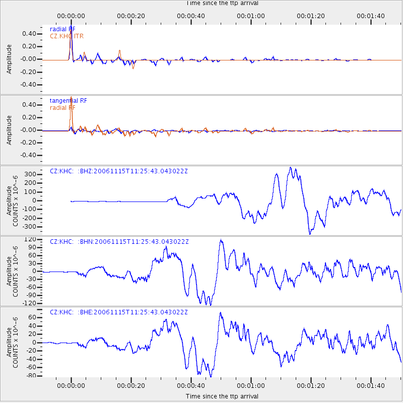
Signal To Noise
| Channel | StoN | STA | LTA |
| CZ:KHC: :BHN:20061115T11:25:43.043022Z | 4.9943123 | 6.7565857E-6 | 1.352856E-6 |
| CZ:KHC: :BHE:20061115T11:25:43.043022Z | 3.039338 | 4.4114677E-6 | 1.4514567E-6 |
| CZ:KHC: :BHZ:20061115T11:25:43.043022Z | 12.092794 | 2.1839787E-5 | 1.8060166E-6 |
| Arrivals |
| Ps | 3.2 SECOND |
| PpPs | 9.0 SECOND |
| PsPs/PpSs | 12 SECOND |


