You are here: Home > Network List > TA - USArray Transportable Network (new EarthScope stations) Stations List
> Station 557A Orange Park, FL, USA > Earthquake Result Viewer
557A Orange Park, FL, USA - Earthquake Result Viewer
| Earthquake location: |
Off W. Coast Of Baja California |
| Earthquake latitude/longitude: |
31.1/-119.7 |
| Earthquake time(UTC): |
2012/12/14 (349) 10:36:01 GMT |
| Earthquake Depth: |
13 km |
| Earthquake Magnitude: |
6.2 MB, 6.1 MS, 6.3 MW, 6.4 MW |
| Earthquake Catalog/Contributor: |
WHDF/NEIC |
|
| Network: |
TA USArray Transportable Network (new EarthScope stations) |
| Station: |
557A Orange Park, FL, USA |
| Lat/Lon: |
30.02 N/81.73 W |
| Elevation: |
24 m |
|
| Distance: |
32.6 deg |
| Az: |
81.951 deg |
| Baz: |
281.675 deg |
| Ray Param: |
0.07858581 |
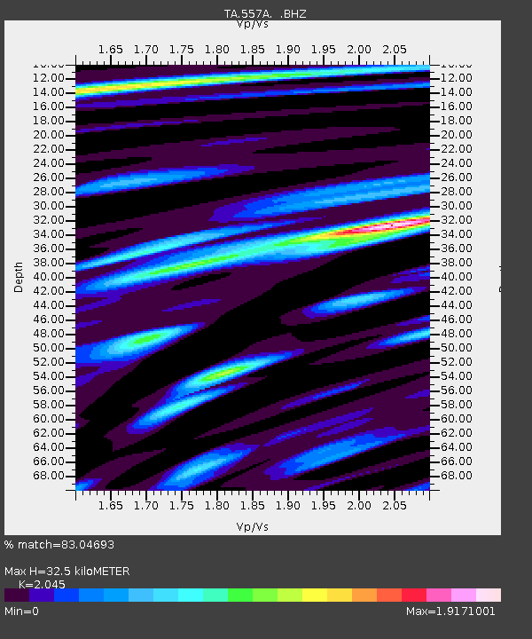
| Estimated Moho Depth: |
32.5 km |
| Estimated Crust Vp/Vs: |
2.05 |
| Assumed Crust Vp: |
5.989 km/s |
| Estimated Crust Vs: |
2.929 km/s |
| Estimated Crust Poisson's Ratio: |
0.34 |
|
| Radial Match: |
83.04693 % |
| Radial Bump: |
400 |
| Transverse Match: |
56.260265 % |
| Transverse Bump: |
400 |
| SOD ConfigId: |
491031 |
| Insert Time: |
2013-04-02 15:56:04.037 +0000 |
| GWidth: |
2.5 |
| Max Bumps: |
400 |
| Tol: |
0.001 |
|

Signal To Noise
| Channel | StoN | STA | LTA |
| TA:557A: :BHZ:20121214T10:42:01.824985Z | 5.1440005 | 2.3996258E-6 | 4.6649023E-7 |
| TA:557A: :BHN:20121214T10:42:01.824985Z | 1.2137064 | 8.0424917E-7 | 6.62639E-7 |
| TA:557A: :BHE:20121214T10:42:01.824985Z | 2.2529943 | 1.938741E-6 | 8.605175E-7 |
| Arrivals |
| Ps | 6.0 SECOND |
| PpPs | 16 SECOND |
| PsPs/PpSs | 22 SECOND |


