You are here: Home > Network List > TA - USArray Transportable Network (new EarthScope stations) Stations List
> Station 757A Oxford, FL, USA > Earthquake Result Viewer
757A Oxford, FL, USA - Earthquake Result Viewer
| Earthquake location: |
Off W. Coast Of Baja California |
| Earthquake latitude/longitude: |
31.1/-119.7 |
| Earthquake time(UTC): |
2012/12/14 (349) 10:36:01 GMT |
| Earthquake Depth: |
13 km |
| Earthquake Magnitude: |
6.2 MB, 6.1 MS, 6.3 MW, 6.4 MW |
| Earthquake Catalog/Contributor: |
WHDF/NEIC |
|
| Network: |
TA USArray Transportable Network (new EarthScope stations) |
| Station: |
757A Oxford, FL, USA |
| Lat/Lon: |
28.94 N/82.07 W |
| Elevation: |
22 m |
|
| Distance: |
32.5 deg |
| Az: |
84.014 deg |
| Baz: |
283.248 deg |
| Ray Param: |
0.07861043 |
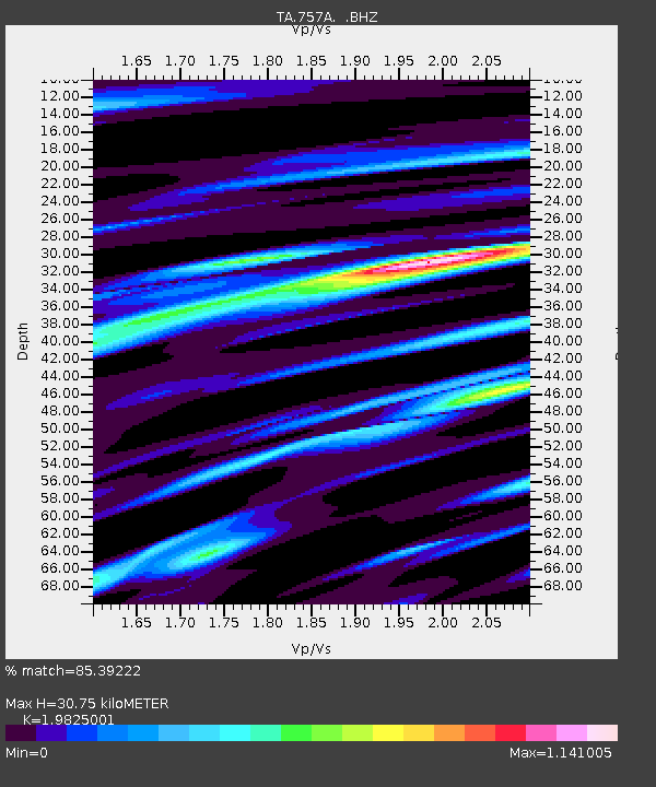
| Estimated Moho Depth: |
30.75 km |
| Estimated Crust Vp/Vs: |
1.98 |
| Assumed Crust Vp: |
5.989 km/s |
| Estimated Crust Vs: |
3.021 km/s |
| Estimated Crust Poisson's Ratio: |
0.33 |
|
| Radial Match: |
85.39222 % |
| Radial Bump: |
400 |
| Transverse Match: |
59.42005 % |
| Transverse Bump: |
400 |
| SOD ConfigId: |
491031 |
| Insert Time: |
2013-04-02 15:56:28.194 +0000 |
| GWidth: |
2.5 |
| Max Bumps: |
400 |
| Tol: |
0.001 |
|
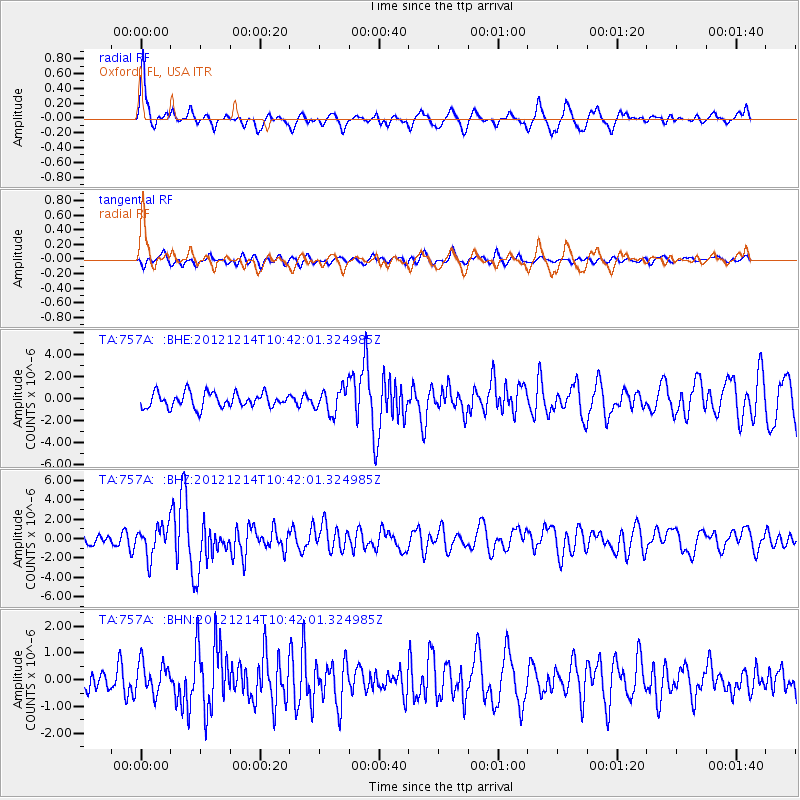
Signal To Noise
| Channel | StoN | STA | LTA |
| TA:757A: :BHZ:20121214T10:42:01.324985Z | 2.7355902 | 1.5419726E-6 | 5.636709E-7 |
| TA:757A: :BHN:20121214T10:42:01.324985Z | 1.2344656 | 5.722134E-7 | 4.6353128E-7 |
| TA:757A: :BHE:20121214T10:42:01.324985Z | 1.6851934 | 1.130722E-6 | 6.709746E-7 |
| Arrivals |
| Ps | 5.4 SECOND |
| PpPs | 14 SECOND |
| PsPs/PpSs | 20 SECOND |


