You are here: Home > Network List > TA - USArray Transportable Network (new EarthScope stations) Stations List
> Station 655A Horseshoe Beach, FL, USA > Earthquake Result Viewer
655A Horseshoe Beach, FL, USA - Earthquake Result Viewer
| Earthquake location: |
Off W. Coast Of Baja California |
| Earthquake latitude/longitude: |
31.1/-119.7 |
| Earthquake time(UTC): |
2012/12/14 (349) 10:36:01 GMT |
| Earthquake Depth: |
13 km |
| Earthquake Magnitude: |
6.2 MB, 6.1 MS, 6.3 MW, 6.4 MW |
| Earthquake Catalog/Contributor: |
WHDF/NEIC |
|
| Network: |
TA USArray Transportable Network (new EarthScope stations) |
| Station: |
655A Horseshoe Beach, FL, USA |
| Lat/Lon: |
29.51 N/83.26 W |
| Elevation: |
6.0 m |
|
| Distance: |
31.4 deg |
| Az: |
83.399 deg |
| Baz: |
282.149 deg |
| Ray Param: |
0.0790797 |
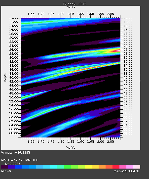
| Estimated Moho Depth: |
26.25 km |
| Estimated Crust Vp/Vs: |
2.10 |
| Assumed Crust Vp: |
5.989 km/s |
| Estimated Crust Vs: |
2.855 km/s |
| Estimated Crust Poisson's Ratio: |
0.35 |
|
| Radial Match: |
89.3385 % |
| Radial Bump: |
334 |
| Transverse Match: |
61.922253 % |
| Transverse Bump: |
380 |
| SOD ConfigId: |
491031 |
| Insert Time: |
2013-04-02 15:56:39.777 +0000 |
| GWidth: |
2.5 |
| Max Bumps: |
400 |
| Tol: |
0.001 |
|

Signal To Noise
| Channel | StoN | STA | LTA |
| TA:655A: :BHZ:20121214T10:41:51.375004Z | 2.4006233 | 1.6830701E-6 | 7.0109706E-7 |
| TA:655A: :BHN:20121214T10:41:51.375004Z | 1.120284 | 6.1630004E-7 | 5.501284E-7 |
| TA:655A: :BHE:20121214T10:41:51.375004Z | 2.2116175 | 9.419282E-7 | 4.2590014E-7 |
| Arrivals |
| Ps | 5.1 SECOND |
| PpPs | 13 SECOND |
| PsPs/PpSs | 18 SECOND |


