You are here: Home > Network List > TA - USArray Transportable Network (new EarthScope stations) Stations List
> Station 355A Pearson, GA, USA > Earthquake Result Viewer
355A Pearson, GA, USA - Earthquake Result Viewer
*The percent match for this event was below the threshold and hence no stack was calculated.
| Earthquake location: |
Off W. Coast Of Baja California |
| Earthquake latitude/longitude: |
31.1/-119.7 |
| Earthquake time(UTC): |
2012/12/14 (349) 10:36:01 GMT |
| Earthquake Depth: |
13 km |
| Earthquake Magnitude: |
6.2 MB, 6.1 MS, 6.3 MW, 6.4 MW |
| Earthquake Catalog/Contributor: |
WHDF/NEIC |
|
| Network: |
TA USArray Transportable Network (new EarthScope stations) |
| Station: |
355A Pearson, GA, USA |
| Lat/Lon: |
31.34 N/82.85 W |
| Elevation: |
69 m |
|
| Distance: |
31.4 deg |
| Az: |
79.827 deg |
| Baz: |
279.303 deg |
| Ray Param: |
$rayparam |
*The percent match for this event was below the threshold and hence was not used in the summary stack. |
|
| Radial Match: |
73.18597 % |
| Radial Bump: |
344 |
| Transverse Match: |
62.84372 % |
| Transverse Bump: |
400 |
| SOD ConfigId: |
491031 |
| Insert Time: |
2013-04-02 15:57:01.379 +0000 |
| GWidth: |
2.5 |
| Max Bumps: |
400 |
| Tol: |
0.001 |
|
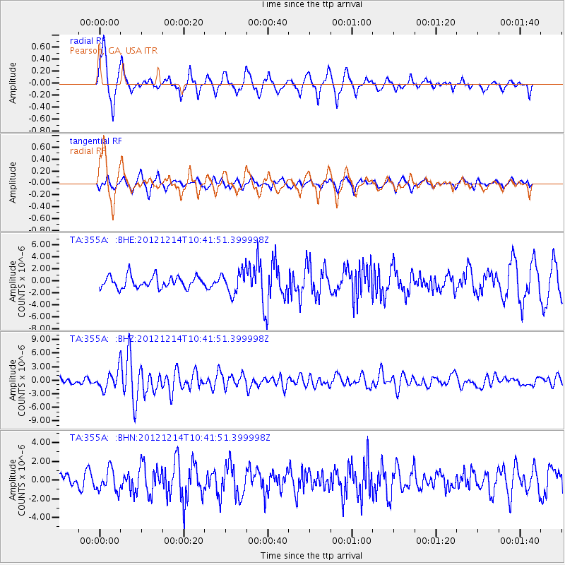
Signal To Noise
| Channel | StoN | STA | LTA |
| TA:355A: :BHZ:20121214T10:41:51.399998Z | 3.2293181 | 2.0659656E-6 | 6.397529E-7 |
| TA:355A: :BHN:20121214T10:41:51.399998Z | 1.371982 | 1.1909748E-6 | 8.6806887E-7 |
| TA:355A: :BHE:20121214T10:41:51.399998Z | 1.9724337 | 1.9282913E-6 | 9.776204E-7 |
| Arrivals |
| Ps | |
| PpPs | |
| PsPs/PpSs | |


