You are here: Home > Network List > TA - USArray Transportable Network (new EarthScope stations) Stations List
> Station 356A Blackshear, GA, USA > Earthquake Result Viewer
356A Blackshear, GA, USA - Earthquake Result Viewer
| Earthquake location: |
Off W. Coast Of Baja California |
| Earthquake latitude/longitude: |
31.1/-119.7 |
| Earthquake time(UTC): |
2012/12/14 (349) 10:36:01 GMT |
| Earthquake Depth: |
13 km |
| Earthquake Magnitude: |
6.2 MB, 6.1 MS, 6.3 MW, 6.4 MW |
| Earthquake Catalog/Contributor: |
WHDF/NEIC |
|
| Network: |
TA USArray Transportable Network (new EarthScope stations) |
| Station: |
356A Blackshear, GA, USA |
| Lat/Lon: |
31.32 N/82.13 W |
| Elevation: |
36 m |
|
| Distance: |
32.0 deg |
| Az: |
79.67 deg |
| Baz: |
279.544 deg |
| Ray Param: |
0.07883146 |
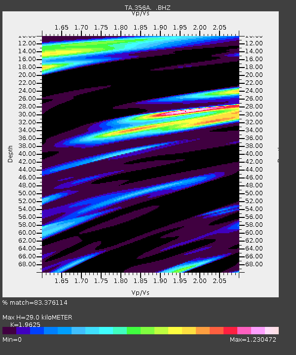
| Estimated Moho Depth: |
29.0 km |
| Estimated Crust Vp/Vs: |
1.96 |
| Assumed Crust Vp: |
6.565 km/s |
| Estimated Crust Vs: |
3.345 km/s |
| Estimated Crust Poisson's Ratio: |
0.32 |
|
| Radial Match: |
83.376114 % |
| Radial Bump: |
400 |
| Transverse Match: |
76.13445 % |
| Transverse Bump: |
400 |
| SOD ConfigId: |
491031 |
| Insert Time: |
2013-04-02 15:57:02.954 +0000 |
| GWidth: |
2.5 |
| Max Bumps: |
400 |
| Tol: |
0.001 |
|

Signal To Noise
| Channel | StoN | STA | LTA |
| TA:356A: :BHZ:20121214T10:41:56.774998Z | 2.0658023 | 2.1154403E-6 | 1.0240285E-6 |
| TA:356A: :BHN:20121214T10:41:56.774998Z | 0.7407041 | 2.1011205E-7 | 2.836653E-7 |
| TA:356A: :BHE:20121214T10:41:56.774998Z | 1.5397494 | 1.7475113E-6 | 1.1349322E-6 |
| Arrivals |
| Ps | 4.6 SECOND |
| PpPs | 12 SECOND |
| PsPs/PpSs | 17 SECOND |


