You are here: Home > Network List > TA - USArray Transportable Network (new EarthScope stations) Stations List
> Station Z55A Blythe, GA, USA > Earthquake Result Viewer
Z55A Blythe, GA, USA - Earthquake Result Viewer
| Earthquake location: |
Off W. Coast Of Baja California |
| Earthquake latitude/longitude: |
31.1/-119.7 |
| Earthquake time(UTC): |
2012/12/14 (349) 10:36:01 GMT |
| Earthquake Depth: |
13 km |
| Earthquake Magnitude: |
6.2 MB, 6.1 MS, 6.3 MW, 6.4 MW |
| Earthquake Catalog/Contributor: |
WHDF/NEIC |
|
| Network: |
TA USArray Transportable Network (new EarthScope stations) |
| Station: |
Z55A Blythe, GA, USA |
| Lat/Lon: |
33.22 N/82.14 W |
| Elevation: |
100 m |
|
| Distance: |
31.7 deg |
| Az: |
76.125 deg |
| Baz: |
276.528 deg |
| Ray Param: |
0.0789469 |
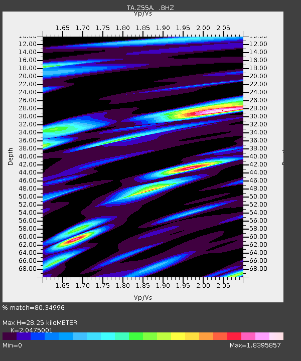
| Estimated Moho Depth: |
28.25 km |
| Estimated Crust Vp/Vs: |
2.05 |
| Assumed Crust Vp: |
6.565 km/s |
| Estimated Crust Vs: |
3.206 km/s |
| Estimated Crust Poisson's Ratio: |
0.34 |
|
| Radial Match: |
80.34996 % |
| Radial Bump: |
400 |
| Transverse Match: |
50.992764 % |
| Transverse Bump: |
347 |
| SOD ConfigId: |
491031 |
| Insert Time: |
2013-04-02 15:57:46.059 +0000 |
| GWidth: |
2.5 |
| Max Bumps: |
400 |
| Tol: |
0.001 |
|
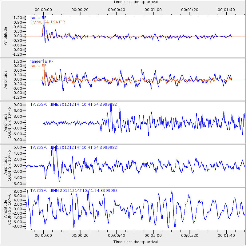
Signal To Noise
| Channel | StoN | STA | LTA |
| TA:Z55A: :BHZ:20121214T10:41:54.399998Z | 6.9494033 | 2.1880678E-6 | 3.1485692E-7 |
| TA:Z55A: :BHN:20121214T10:41:54.399998Z | 0.740582 | 3.8795633E-6 | 5.238533E-6 |
| TA:Z55A: :BHE:20121214T10:41:54.399998Z | 3.602641 | 1.6785272E-6 | 4.6591572E-7 |
| Arrivals |
| Ps | 4.8 SECOND |
| PpPs | 12 SECOND |
| PsPs/PpSs | 17 SECOND |


