You are here: Home > Network List > TA - USArray Transportable Network (new EarthScope stations) Stations List
> Station Y54A Tignall, GA, USA > Earthquake Result Viewer
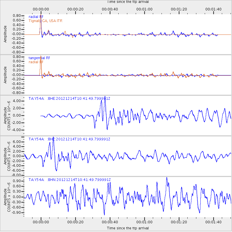
Y54A Tignall, GA, USA - Earthquake Result Viewer
*The percent match for this event was below the threshold and hence no stack was calculated.
| Earthquake location: |
Off W. Coast Of Baja California |
| Earthquake latitude/longitude: |
31.1/-119.7 |
| Earthquake time(UTC): |
2012/12/14 (349) 10:36:01 GMT |
| Earthquake Depth: |
13 km |
| Earthquake Magnitude: |
6.2 MB, 6.1 MS, 6.3 MW, 6.4 MW |
| Earthquake Catalog/Contributor: |
WHDF/NEIC |
|
| Network: |
TA USArray Transportable Network (new EarthScope stations) |
| Station: |
Y54A Tignall, GA, USA |
| Lat/Lon: |
33.86 N/82.69 W |
| Elevation: |
176 m |
|
| Distance: |
31.2 deg |
| Az: |
74.997 deg |
| Baz: |
275.263 deg |
| Ray Param: |
$rayparam |
*The percent match for this event was below the threshold and hence was not used in the summary stack. |
|
| Radial Match: |
77.942894 % |
| Radial Bump: |
250 |
| Transverse Match: |
52.092175 % |
| Transverse Bump: |
400 |
| SOD ConfigId: |
491031 |
| Insert Time: |
2013-04-02 15:58:06.749 +0000 |
| GWidth: |
2.5 |
| Max Bumps: |
400 |
| Tol: |
0.001 |
|
Signal To Noise
| Channel | StoN | STA | LTA |
| TA:Y54A: :BHZ:20121214T10:41:49.799991Z | 3.3790247 | 2.0617476E-6 | 6.101605E-7 |
| TA:Y54A: :BHN:20121214T10:41:49.799991Z | 0.5587707 | 1.9765719E-7 | 3.5373574E-7 |
| TA:Y54A: :BHE:20121214T10:41:49.799991Z | 5.254868 | 1.6146773E-6 | 3.0727264E-7 |
| Arrivals |
| Ps | |
| PpPs | |
| PsPs/PpSs | |


