You are here: Home > Network List > TA - USArray Transportable Network (new EarthScope stations) Stations List
> Station M50A Fremont, OH, USA > Earthquake Result Viewer
M50A Fremont, OH, USA - Earthquake Result Viewer
| Earthquake location: |
Off W. Coast Of Baja California |
| Earthquake latitude/longitude: |
31.1/-119.7 |
| Earthquake time(UTC): |
2012/12/14 (349) 10:36:01 GMT |
| Earthquake Depth: |
13 km |
| Earthquake Magnitude: |
6.2 MB, 6.1 MS, 6.3 MW, 6.4 MW |
| Earthquake Catalog/Contributor: |
WHDF/NEIC |
|
| Network: |
TA USArray Transportable Network (new EarthScope stations) |
| Station: |
M50A Fremont, OH, USA |
| Lat/Lon: |
41.40 N/83.04 W |
| Elevation: |
176 m |
|
| Distance: |
31.1 deg |
| Az: |
60.401 deg |
| Baz: |
262.535 deg |
| Ray Param: |
0.079163045 |
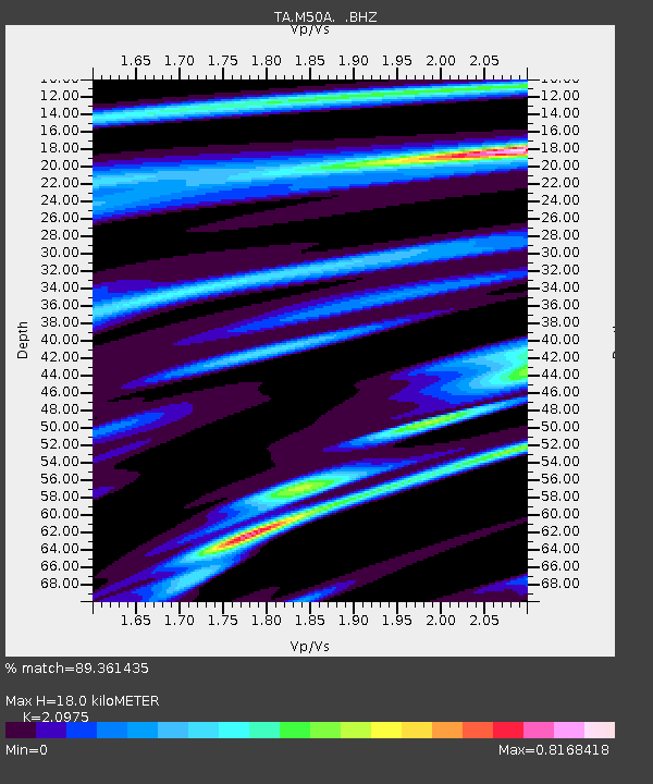
| Estimated Moho Depth: |
18.0 km |
| Estimated Crust Vp/Vs: |
2.10 |
| Assumed Crust Vp: |
6.498 km/s |
| Estimated Crust Vs: |
3.098 km/s |
| Estimated Crust Poisson's Ratio: |
0.35 |
|
| Radial Match: |
89.361435 % |
| Radial Bump: |
229 |
| Transverse Match: |
64.57617 % |
| Transverse Bump: |
400 |
| SOD ConfigId: |
491031 |
| Insert Time: |
2013-04-02 15:59:42.342 +0000 |
| GWidth: |
2.5 |
| Max Bumps: |
400 |
| Tol: |
0.001 |
|
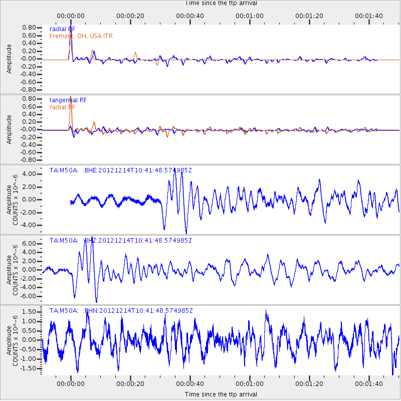
Signal To Noise
| Channel | StoN | STA | LTA |
| TA:M50A: :BHZ:20121214T10:41:48.574985Z | 5.6460414 | 3.355547E-6 | 5.943185E-7 |
| TA:M50A: :BHN:20121214T10:41:48.574985Z | 1.3735511 | 7.182461E-7 | 5.229118E-7 |
| TA:M50A: :BHE:20121214T10:41:48.574985Z | 4.906053 | 2.3221637E-6 | 4.7332628E-7 |
| Arrivals |
| Ps | 3.3 SECOND |
| PpPs | 8.0 SECOND |
| PsPs/PpSs | 11 SECOND |


