You are here: Home > Network List > TA - USArray Transportable Network (new EarthScope stations) Stations List
> Station P51A Williamsport, OH, USA > Earthquake Result Viewer
P51A Williamsport, OH, USA - Earthquake Result Viewer
| Earthquake location: |
Off W. Coast Of Baja California |
| Earthquake latitude/longitude: |
31.1/-119.7 |
| Earthquake time(UTC): |
2012/12/14 (349) 10:36:01 GMT |
| Earthquake Depth: |
13 km |
| Earthquake Magnitude: |
6.2 MB, 6.1 MS, 6.3 MW, 6.4 MW |
| Earthquake Catalog/Contributor: |
WHDF/NEIC |
|
| Network: |
TA USArray Transportable Network (new EarthScope stations) |
| Station: |
P51A Williamsport, OH, USA |
| Lat/Lon: |
39.48 N/83.06 W |
| Elevation: |
211 m |
|
| Distance: |
30.9 deg |
| Az: |
64.11 deg |
| Baz: |
265.705 deg |
| Ray Param: |
0.07921818 |
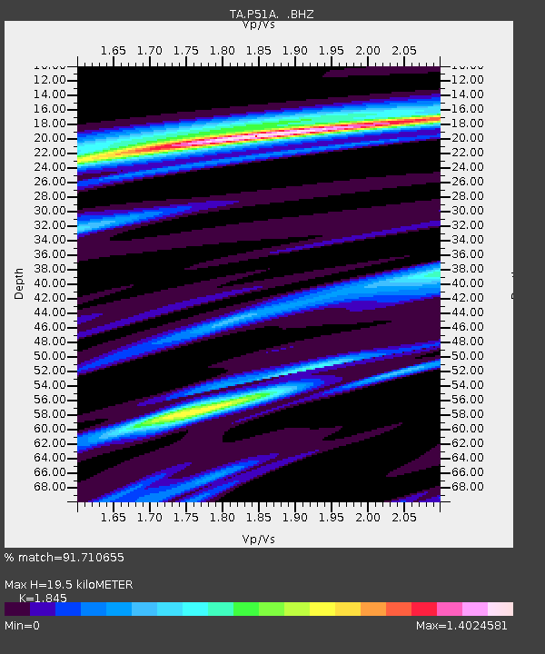
| Estimated Moho Depth: |
19.5 km |
| Estimated Crust Vp/Vs: |
1.85 |
| Assumed Crust Vp: |
6.232 km/s |
| Estimated Crust Vs: |
3.378 km/s |
| Estimated Crust Poisson's Ratio: |
0.29 |
|
| Radial Match: |
91.710655 % |
| Radial Bump: |
289 |
| Transverse Match: |
76.34166 % |
| Transverse Bump: |
400 |
| SOD ConfigId: |
491031 |
| Insert Time: |
2013-04-02 15:59:56.226 +0000 |
| GWidth: |
2.5 |
| Max Bumps: |
400 |
| Tol: |
0.001 |
|
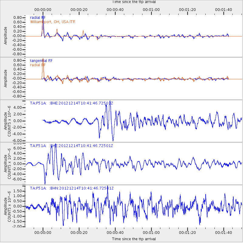
Signal To Noise
| Channel | StoN | STA | LTA |
| TA:P51A: :BHZ:20121214T10:41:46.72501Z | 12.425974 | 3.6770932E-6 | 2.9591993E-7 |
| TA:P51A: :BHN:20121214T10:41:46.72501Z | 1.3085818 | 3.463524E-7 | 2.6467768E-7 |
| TA:P51A: :BHE:20121214T10:41:46.72501Z | 4.7514296 | 2.1371714E-6 | 4.4979544E-7 |
| Arrivals |
| Ps | 2.8 SECOND |
| PpPs | 8.3 SECOND |
| PsPs/PpSs | 11 SECOND |


