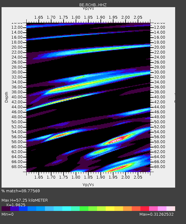
RCHB Rochefort, Belgium - Earthquake Result Viewer

Earthquake location: Rat Islands, Aleutian Islands
Earthquake latitude/longitude: 52.3/176.7
Earthquake time(UTC): 2014/06/24 (175) 03:15:36 GMT
Earthquake Depth: 4.0 km
Earthquake Magnitude: 6.3 MWB, 5.7 ML, 6.4 MWC, 6.6 MI
Earthquake Catalog/Contributor: NEIC PDE/NEIC COMCAT
Network: BE Belgian Seismic Network
Station: RCHB Rochefort, Belgium
Lat/Lon: 50.16 N/5.23 E
Elevation: 191 m
Distance: 77.7 deg
Az: 354.408 deg
Baz: 5.344 deg
Ray Param: 0.050147124
Estimated Moho Depth: 57.25 km
Estimated Crust Vp/Vs: 1.96
Assumed Crust Vp: 6.276 km/s
Estimated Crust Vs: 3.198 km/s
Estimated Crust Poisson's Ratio: 0.32
Radial Match: 89.77569 %
Radial Bump: 375
Transverse Match: 70.487015 %
Transverse Bump: 400
SOD ConfigId: 3390531
Insert Time: 2019-04-12 12:19:34.858 +0000
GWidth: 2.5
Max Bumps: 400
Tol: 0.001

Signal To Noise

ChannelStoNSTALTA
BE:RCHB: :HHZ:20140624T03:27:03.827996Z1.71109592.1082127E-71.2320834E-7
BE:RCHB: :HHN:20140624T03:27:03.827996Z0.609596255.641834E-89.255034E-8
BE:RCHB: :HHE:20140624T03:27:03.827996Z0.82166235.2561454E-86.396965E-8
Arrivals
Ps9.0 SECOND
PpPs26 SECOND
PsPs/PpSs35 SECOND