You are here: Home > Network List > TA - USArray Transportable Network (new EarthScope stations) Stations List
> Station E50A Wahnapitae, ON, CAN > Earthquake Result Viewer
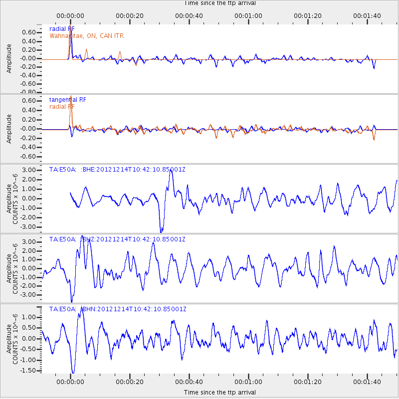
E50A Wahnapitae, ON, CAN - Earthquake Result Viewer
*The percent match for this event was below the threshold and hence no stack was calculated.
| Earthquake location: |
Off W. Coast Of Baja California |
| Earthquake latitude/longitude: |
31.1/-119.7 |
| Earthquake time(UTC): |
2012/12/14 (349) 10:36:01 GMT |
| Earthquake Depth: |
13 km |
| Earthquake Magnitude: |
6.2 MB, 6.1 MS, 6.3 MW, 6.4 MW |
| Earthquake Catalog/Contributor: |
WHDF/NEIC |
|
| Network: |
TA USArray Transportable Network (new EarthScope stations) |
| Station: |
E50A Wahnapitae, ON, CAN |
| Lat/Lon: |
46.42 N/80.74 W |
| Elevation: |
242 m |
|
| Distance: |
33.6 deg |
| Az: |
51.727 deg |
| Baz: |
256.796 deg |
| Ray Param: |
$rayparam |
*The percent match for this event was below the threshold and hence was not used in the summary stack. |
|
| Radial Match: |
74.988 % |
| Radial Bump: |
283 |
| Transverse Match: |
56.95564 % |
| Transverse Bump: |
400 |
| SOD ConfigId: |
491031 |
| Insert Time: |
2013-04-02 16:02:35.552 +0000 |
| GWidth: |
2.5 |
| Max Bumps: |
400 |
| Tol: |
0.001 |
|
Signal To Noise
| Channel | StoN | STA | LTA |
| TA:E50A: :BHZ:20121214T10:42:10.85001Z | 3.1259465 | 2.5049576E-6 | 8.0134373E-7 |
| TA:E50A: :BHN:20121214T10:42:10.85001Z | 2.7356882 | 1.0544017E-6 | 3.854246E-7 |
| TA:E50A: :BHE:20121214T10:42:10.85001Z | 4.805985 | 2.1645583E-6 | 4.503881E-7 |
| Arrivals |
| Ps | |
| PpPs | |
| PsPs/PpSs | |


