You are here: Home > Network List > TA - USArray Transportable Network (new EarthScope stations) Stations List
> Station F52A Sundridge, ON, CAN > Earthquake Result Viewer
F52A Sundridge, ON, CAN - Earthquake Result Viewer
| Earthquake location: |
Off W. Coast Of Baja California |
| Earthquake latitude/longitude: |
31.1/-119.7 |
| Earthquake time(UTC): |
2012/12/14 (349) 10:36:01 GMT |
| Earthquake Depth: |
13 km |
| Earthquake Magnitude: |
6.2 MB, 6.1 MS, 6.3 MW, 6.4 MW |
| Earthquake Catalog/Contributor: |
WHDF/NEIC |
|
| Network: |
TA USArray Transportable Network (new EarthScope stations) |
| Station: |
F52A Sundridge, ON, CAN |
| Lat/Lon: |
45.80 N/79.32 W |
| Elevation: |
351 m |
|
| Distance: |
34.4 deg |
| Az: |
53.193 deg |
| Baz: |
259.028 deg |
| Ray Param: |
0.077731244 |
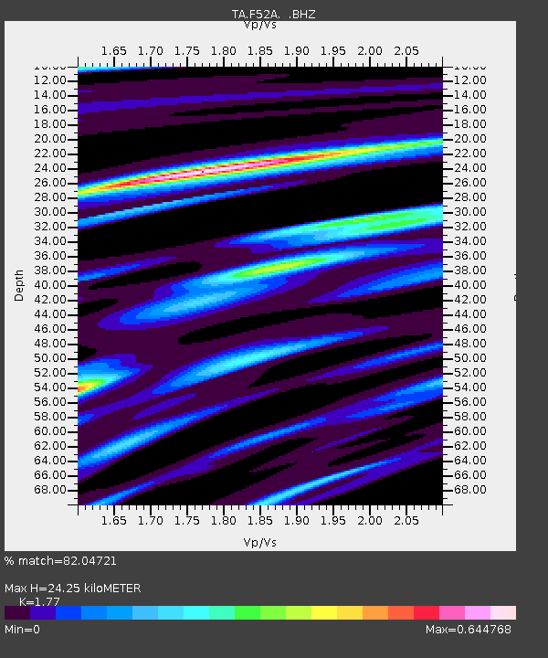
| Estimated Moho Depth: |
24.25 km |
| Estimated Crust Vp/Vs: |
1.77 |
| Assumed Crust Vp: |
6.577 km/s |
| Estimated Crust Vs: |
3.716 km/s |
| Estimated Crust Poisson's Ratio: |
0.27 |
|
| Radial Match: |
82.04721 % |
| Radial Bump: |
316 |
| Transverse Match: |
60.258354 % |
| Transverse Bump: |
400 |
| SOD ConfigId: |
491031 |
| Insert Time: |
2013-04-02 16:02:44.709 +0000 |
| GWidth: |
2.5 |
| Max Bumps: |
400 |
| Tol: |
0.001 |
|
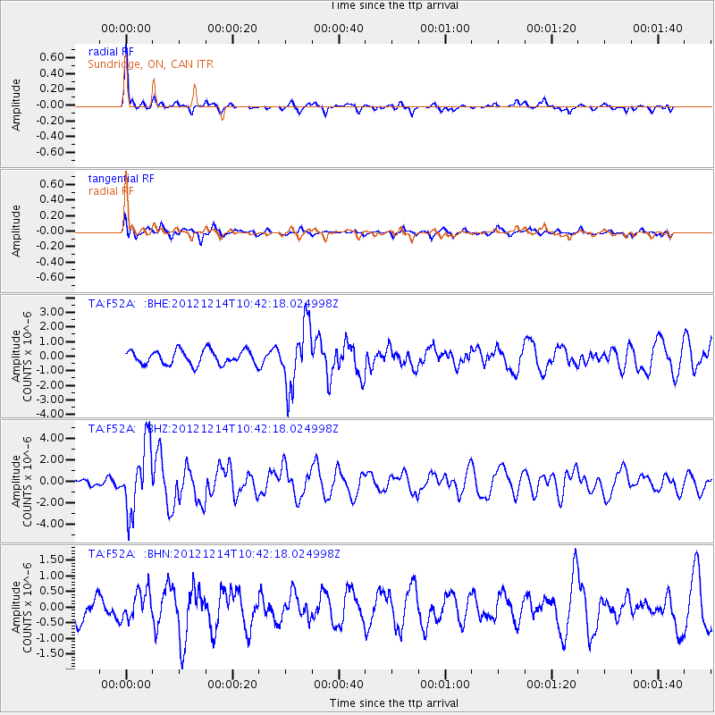
Signal To Noise
| Channel | StoN | STA | LTA |
| TA:F52A: :BHZ:20121214T10:42:18.024998Z | 6.119069 | 3.148391E-6 | 5.145212E-7 |
| TA:F52A: :BHN:20121214T10:42:18.024998Z | 1.0005808 | 4.572095E-7 | 4.569441E-7 |
| TA:F52A: :BHE:20121214T10:42:18.024998Z | 4.4366455 | 2.117986E-6 | 4.7738456E-7 |
| Arrivals |
| Ps | 3.1 SECOND |
| PpPs | 9.4 SECOND |
| PsPs/PpSs | 12 SECOND |


