You are here: Home > Network List > TA - USArray Transportable Network (new EarthScope stations) Stations List
> Station E48A Lockeyer, ON, CAN > Earthquake Result Viewer
E48A Lockeyer, ON, CAN - Earthquake Result Viewer
| Earthquake location: |
Off W. Coast Of Baja California |
| Earthquake latitude/longitude: |
31.1/-119.7 |
| Earthquake time(UTC): |
2012/12/14 (349) 10:36:01 GMT |
| Earthquake Depth: |
13 km |
| Earthquake Magnitude: |
6.2 MB, 6.1 MS, 6.3 MW, 6.4 MW |
| Earthquake Catalog/Contributor: |
WHDF/NEIC |
|
| Network: |
TA USArray Transportable Network (new EarthScope stations) |
| Station: |
E48A Lockeyer, ON, CAN |
| Lat/Lon: |
46.48 N/82.17 W |
| Elevation: |
347 m |
|
| Distance: |
32.7 deg |
| Az: |
51.19 deg |
| Baz: |
255.315 deg |
| Ray Param: |
0.07854744 |
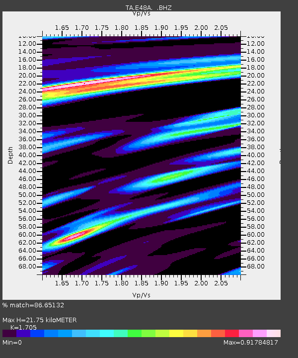
| Estimated Moho Depth: |
21.75 km |
| Estimated Crust Vp/Vs: |
1.71 |
| Assumed Crust Vp: |
6.467 km/s |
| Estimated Crust Vs: |
3.793 km/s |
| Estimated Crust Poisson's Ratio: |
0.24 |
|
| Radial Match: |
86.65132 % |
| Radial Bump: |
357 |
| Transverse Match: |
57.666664 % |
| Transverse Bump: |
400 |
| SOD ConfigId: |
491031 |
| Insert Time: |
2013-04-02 16:02:47.175 +0000 |
| GWidth: |
2.5 |
| Max Bumps: |
400 |
| Tol: |
0.001 |
|
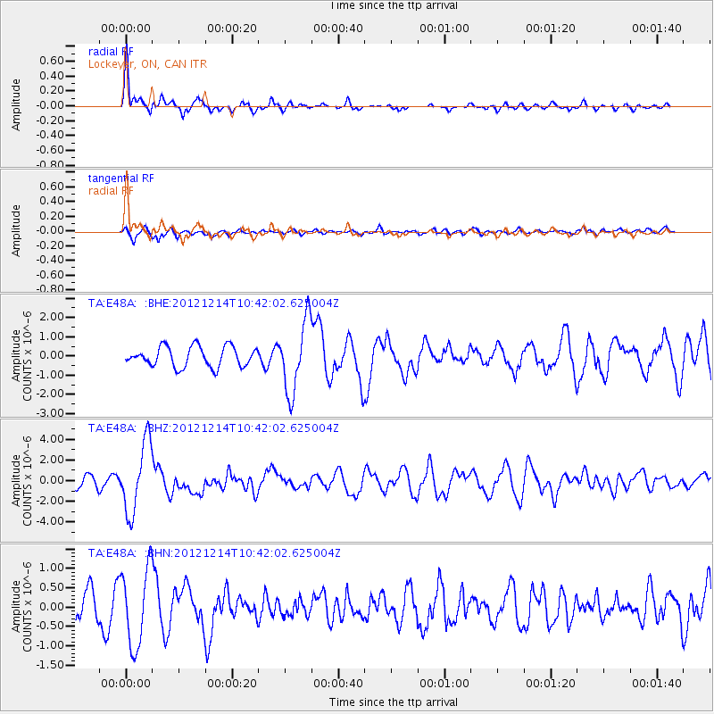
Signal To Noise
| Channel | StoN | STA | LTA |
| TA:E48A: :BHZ:20121214T10:42:02.625004Z | 5.8016434 | 3.4155985E-6 | 5.8872945E-7 |
| TA:E48A: :BHN:20121214T10:42:02.625004Z | 2.640573 | 1.0097929E-6 | 3.8241427E-7 |
| TA:E48A: :BHE:20121214T10:42:02.625004Z | 3.6022441 | 1.8678079E-6 | 5.185123E-7 |
| Arrivals |
| Ps | 2.6 SECOND |
| PpPs | 8.4 SECOND |
| PsPs/PpSs | 11 SECOND |


