You are here: Home > Network List > TA - USArray Transportable Network (new EarthScope stations) Stations List
> Station I55A Frankford, ON, CAN > Earthquake Result Viewer
I55A Frankford, ON, CAN - Earthquake Result Viewer
| Earthquake location: |
Off W. Coast Of Baja California |
| Earthquake latitude/longitude: |
31.1/-119.7 |
| Earthquake time(UTC): |
2012/12/14 (349) 10:36:01 GMT |
| Earthquake Depth: |
13 km |
| Earthquake Magnitude: |
6.2 MB, 6.1 MS, 6.3 MW, 6.4 MW |
| Earthquake Catalog/Contributor: |
WHDF/NEIC |
|
| Network: |
TA USArray Transportable Network (new EarthScope stations) |
| Station: |
I55A Frankford, ON, CAN |
| Lat/Lon: |
44.22 N/77.68 W |
| Elevation: |
132 m |
|
| Distance: |
35.3 deg |
| Az: |
56.242 deg |
| Baz: |
262.685 deg |
| Ray Param: |
0.07726661 |
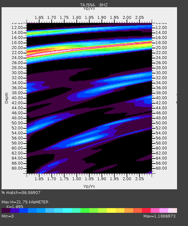
| Estimated Moho Depth: |
21.75 km |
| Estimated Crust Vp/Vs: |
1.70 |
| Assumed Crust Vp: |
6.577 km/s |
| Estimated Crust Vs: |
3.88 km/s |
| Estimated Crust Poisson's Ratio: |
0.23 |
|
| Radial Match: |
86.86907 % |
| Radial Bump: |
370 |
| Transverse Match: |
62.50531 % |
| Transverse Bump: |
400 |
| SOD ConfigId: |
491031 |
| Insert Time: |
2013-04-02 16:04:06.322 +0000 |
| GWidth: |
2.5 |
| Max Bumps: |
400 |
| Tol: |
0.001 |
|
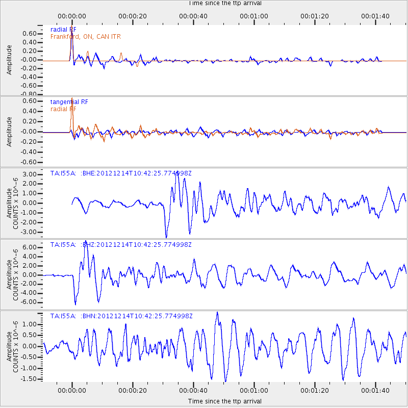
Signal To Noise
| Channel | StoN | STA | LTA |
| TA:I55A: :BHZ:20121214T10:42:25.774998Z | 6.7196636 | 3.7777252E-6 | 5.621896E-7 |
| TA:I55A: :BHN:20121214T10:42:25.774998Z | 1.0884571 | 3.419013E-7 | 3.1411557E-7 |
| TA:I55A: :BHE:20121214T10:42:25.774998Z | 5.5997715 | 1.8966449E-6 | 3.387004E-7 |
| Arrivals |
| Ps | 2.5 SECOND |
| PpPs | 8.2 SECOND |
| PsPs/PpSs | 11 SECOND |


