You are here: Home > Network List > TA - USArray Transportable Network (new EarthScope stations) Stations List
> Station G53A Haliburton, ON, CAN > Earthquake Result Viewer
G53A Haliburton, ON, CAN - Earthquake Result Viewer
| Earthquake location: |
Off W. Coast Of Baja California |
| Earthquake latitude/longitude: |
31.1/-119.7 |
| Earthquake time(UTC): |
2012/12/14 (349) 10:36:01 GMT |
| Earthquake Depth: |
13 km |
| Earthquake Magnitude: |
6.2 MB, 6.1 MS, 6.3 MW, 6.4 MW |
| Earthquake Catalog/Contributor: |
WHDF/NEIC |
|
| Network: |
TA USArray Transportable Network (new EarthScope stations) |
| Station: |
G53A Haliburton, ON, CAN |
| Lat/Lon: |
45.12 N/78.62 W |
| Elevation: |
333 m |
|
| Distance: |
34.8 deg |
| Az: |
54.512 deg |
| Baz: |
260.609 deg |
| Ray Param: |
0.0775424 |
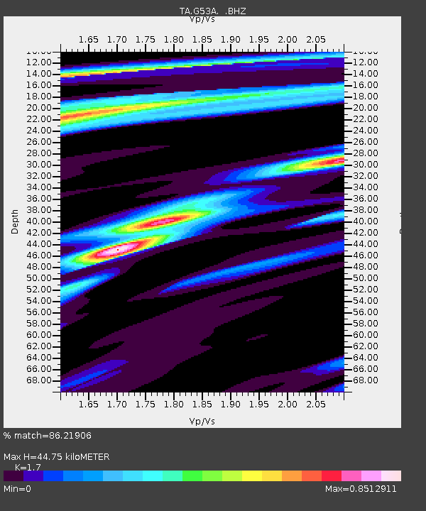
| Estimated Moho Depth: |
44.75 km |
| Estimated Crust Vp/Vs: |
1.70 |
| Assumed Crust Vp: |
6.577 km/s |
| Estimated Crust Vs: |
3.869 km/s |
| Estimated Crust Poisson's Ratio: |
0.24 |
|
| Radial Match: |
86.21906 % |
| Radial Bump: |
236 |
| Transverse Match: |
61.0261 % |
| Transverse Bump: |
343 |
| SOD ConfigId: |
491031 |
| Insert Time: |
2013-04-02 16:04:14.910 +0000 |
| GWidth: |
2.5 |
| Max Bumps: |
400 |
| Tol: |
0.001 |
|

Signal To Noise
| Channel | StoN | STA | LTA |
| TA:G53A: :BHZ:20121214T10:42:21.174991Z | 5.314591 | 3.6501456E-6 | 6.868159E-7 |
| TA:G53A: :BHN:20121214T10:42:21.174991Z | 1.195245 | 6.385262E-7 | 5.3422207E-7 |
| TA:G53A: :BHE:20121214T10:42:21.174991Z | 13.125132 | 2.6024165E-6 | 1.9827738E-7 |
| Arrivals |
| Ps | 5.2 SECOND |
| PpPs | 17 SECOND |
| PsPs/PpSs | 22 SECOND |


