You are here: Home > Network List > TA - USArray Transportable Network (new EarthScope stations) Stations List
> Station N53A Lisbon, OH, USA > Earthquake Result Viewer
N53A Lisbon, OH, USA - Earthquake Result Viewer
| Earthquake location: |
Off W. Coast Of Baja California |
| Earthquake latitude/longitude: |
31.1/-119.7 |
| Earthquake time(UTC): |
2012/12/14 (349) 10:36:01 GMT |
| Earthquake Depth: |
13 km |
| Earthquake Magnitude: |
6.2 MB, 6.1 MS, 6.3 MW, 6.4 MW |
| Earthquake Catalog/Contributor: |
WHDF/NEIC |
|
| Network: |
TA USArray Transportable Network (new EarthScope stations) |
| Station: |
N53A Lisbon, OH, USA |
| Lat/Lon: |
40.81 N/80.84 W |
| Elevation: |
360 m |
|
| Distance: |
32.7 deg |
| Az: |
61.861 deg |
| Baz: |
265.22 deg |
| Ray Param: |
0.07855112 |
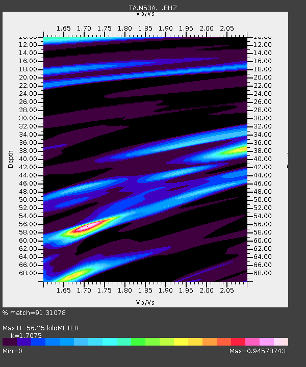
| Estimated Moho Depth: |
56.25 km |
| Estimated Crust Vp/Vs: |
1.71 |
| Assumed Crust Vp: |
6.483 km/s |
| Estimated Crust Vs: |
3.797 km/s |
| Estimated Crust Poisson's Ratio: |
0.24 |
|
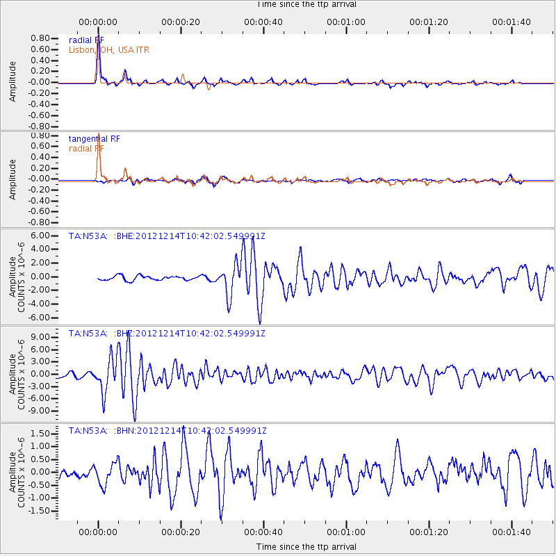
| Radial Match: |
91.31078 % |
| Radial Bump: |
214 |
| Transverse Match: |
70.24543 % |
| Transverse Bump: |
400 |
| SOD ConfigId: |
491031 |
| Insert Time: |
2013-04-02 16:04:55.153 +0000 |
| GWidth: |
2.5 |
| Max Bumps: |
400 |
| Tol: |
0.001 |
|
Signal To Noise
| Channel | StoN | STA | LTA |
| TA:N53A: :BHZ:20121214T10:42:02.549991Z | 7.818249 | 4.2793154E-6 | 5.4734954E-7 |
| TA:N53A: :BHN:20121214T10:42:02.549991Z | 1.1887307 | 4.3502016E-7 | 3.659535E-7 |
| TA:N53A: :BHE:20121214T10:42:02.549991Z | 7.3572493 | 2.408413E-6 | 3.2735235E-7 |
| Arrivals |
| Ps | 6.7 SECOND |
| PpPs | 22 SECOND |
| PsPs/PpSs | 28 SECOND |


